IMAGES TAKEN NEAR TO
Dryden Road, TOWCESTER, NN12 6EE
Introduction
This page details the photographs taken nearby to Dryden Road, NN12 6EE by members of the Geograph project.
The Geograph project started in 2005 with the aim of publishing, organising and preserving representative images for every square kilometre of Great Britain, Ireland and the Isle of Man.

There are currently over 7.5m images from over14,400 individuals and you can help contribute to the project by visiting https://www.geograph.org.uk
Image Map
Images are licensed for reuse under creativecommons.org/licenses/by-sa/2.0
Notes
- Clicking on the map will re-center to the selected point.
- The higher the marker number, the further away the image location is from the centre of the postcode.
Image Listing (7 Images Found)
Images are licensed for reuse under creativecommons.org/licenses/by-sa/2.0
Image
Details
Distance
1
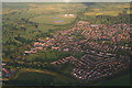
Towcester and Towcester Racecourse: aerial 2015
A5 Watling Street running to the top centre, and Easton Neston Park left.
Image: © Chris
Taken: 28 May 2015
0.13 miles
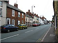
2
Towcester
A view of Burcote Road, close to the veterinary practice.
Image: © Ian Rob
Taken: 20 Feb 2007
0.20 miles
3
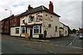
The White Bear is closed
Another pub up for sale.
Image: © David Lally
Taken: 7 Aug 2010
0.23 miles
4
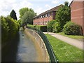
Stream off Watling Street, Towcester
An urban stream with concrete walls, unusually clean.
Image: © Humphrey Bolton
Taken: 1 Jun 2007
0.24 miles
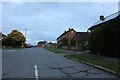
5
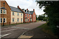
Reffield Close
New housing just off the A5 in Towcester.
Image: © David Lally
Taken: 7 Aug 2010
0.24 miles