IMAGES TAKEN NEAR TO
Cross Lane, DAVENTRY, NN11 7HH
Introduction
This page details the photographs taken nearby to Cross Lane, NN11 7HH by members of the Geograph project.
The Geograph project started in 2005 with the aim of publishing, organising and preserving representative images for every square kilometre of Great Britain, Ireland and the Isle of Man.

There are currently over 7.5m images from over14,400 individuals and you can help contribute to the project by visiting https://www.geograph.org.uk
Image Map
Images are licensed for reuse under creativecommons.org/licenses/by-sa/2.0
Notes
- Clicking on the map will re-center to the selected point.
- The higher the marker number, the further away the image location is from the centre of the postcode.
Image Listing (286 Images Found)
Images are licensed for reuse under creativecommons.org/licenses/by-sa/2.0
Image
Details
Distance
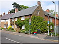
1
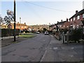
Braunston-Cross Lane
Looking down towards Archer Avenue.
Image: © Ian Rob
Taken: 8 Feb 2011
0.01 miles
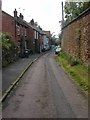
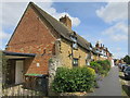
3
Braunston Old Bakehouse
The bakehouse on High street , only stopped trading in 1999.
Image: © Ian Rob
Taken: 29 May 2008
0.06 miles
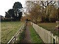
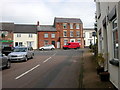
4
Braunston-Nibbits Lane
The lane ends just past the cottages and becomes a footpath down to the marina.
Image: © Ian Rob
Taken: 29 May 2008
0.07 miles
5
Braunston-High Street
Cottage on the corner of the one way street to Church Road.
Image: © Ian Rob
Taken: 29 May 2008
0.07 miles
6
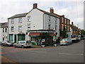
Braunston Butchers Shop
On the corner of High Street and Cross Lane.
Image: © Ian Rob
Taken: 29 May 2008
0.07 miles
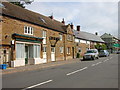
8
Braunston High Street
Buildings on High Street, looking from Cross Lane.
Image: © Ian Rob
Taken: 29 May 2008
0.07 miles
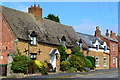
10
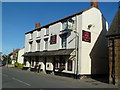
The Old Plough
On Braunston High Street.
Image: © Graham Hogg
Taken: 24 May 2011
0.08 miles