IMAGES TAKEN NEAR TO
Barby Road, DAVENTRY, NN11 7HF
Introduction
This page details the photographs taken nearby to Barby Road, NN11 7HF by members of the Geograph project.
The Geograph project started in 2005 with the aim of publishing, organising and preserving representative images for every square kilometre of Great Britain, Ireland and the Isle of Man.

There are currently over 7.5m images from over14,400 individuals and you can help contribute to the project by visiting https://www.geograph.org.uk
Image Map (Loading...)


Getting Data...Please wait
Leaflet Map data © OpenStreetMap
Images are licensed for reuse under creativecommons.org/licenses/by-sa/2.0
Notes
- Clicking on the map will re-center to the selected point.
- The higher the marker number, the further away the image location is from the centre of the postcode.
Image Listing (48 Images Found)
Images are licensed for reuse under creativecommons.org/licenses/by-sa/2.0
Image
Details
Distance
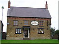
1
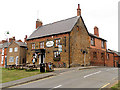
Braunston
Wheatsheaf Pub on corner of Barby Lane
Image: © Ian Rob
Taken: 12 Sep 2005
0.03 miles
2
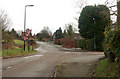
Junction of Barby Lane and Greenway, Braunston
Image: © Andy F
Taken: 31 Dec 2009
0.04 miles
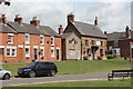
4
The Wheatsheaf Pub, Braunston
The Green, Braunston, Daventry, NN11 7HW near to the Grand Union Canal
Image: © canalandriversidepubs co uk
Taken: 7 Feb 2010
0.06 miles
5
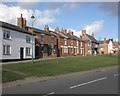
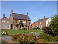
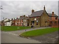
Houses on the village green, Braunston
Image: © Roger Cornfoot
Taken: 8 Oct 2013
0.06 miles
7
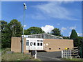
Telephone Exchange, Braunston
Situated in Barby Road opposite Church Road, this TE also serves Ashby St Ledgers, Barby, Flecknoe, Sawbridge and Willoughby nearby, in addition to Braunston. The microwave dishes at the top of the pole on the left of the photo are directed towards the BT microwave radio station near Charwelton, SP5156 refers. The postcode of this TE is NN11 7HF.
Image: © David Hillas
Taken: 11 Sep 2010
0.07 miles
8
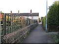
Braunston Footpath
Leading from Church Road to High Street.
Image: © Ian Rob
Taken: 8 Feb 2011
0.07 miles
9
Braunston-Wheatsheaf Inn
Pub and adjoining cottages on The Green.
Image: © Ian Rob
Taken: 1 Mar 2011
0.08 miles
10
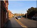
Braunston High Street
The footpath is raised at this point.
Image: © Ian Rob
Taken: 8 Feb 2011
0.08 miles