IMAGES TAKEN NEAR TO
Charwelton Road, DAVENTRY, NN11 6YH
Introduction
This page details the photographs taken nearby to Charwelton Road, NN11 6YH by members of the Geograph project.
The Geograph project started in 2005 with the aim of publishing, organising and preserving representative images for every square kilometre of Great Britain, Ireland and the Isle of Man.

There are currently over 7.5m images from over14,400 individuals and you can help contribute to the project by visiting https://www.geograph.org.uk
Image Map (Loading...)


Getting Data...Please wait
Leaflet Map data © OpenStreetMap
Images are licensed for reuse under creativecommons.org/licenses/by-sa/2.0
Notes
- Clicking on the map will re-center to the selected point.
- The higher the marker number, the further away the image location is from the centre of the postcode.
Image Listing (3 Images Found)
Images are licensed for reuse under creativecommons.org/licenses/by-sa/2.0
Image
Details
Distance
2
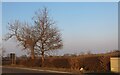
Badby Road West between Byfield and Charwelton
Somebody has knocked the arrow sign off its pole and rested it up against the hedge.
Image: © David Howard
Taken: 20 Mar 2022
0.12 miles