IMAGES TAKEN NEAR TO
Well Lane, DAVENTRY, NN11 6WL
Introduction
This page details the photographs taken nearby to Well Lane, NN11 6WL by members of the Geograph project.
The Geograph project started in 2005 with the aim of publishing, organising and preserving representative images for every square kilometre of Great Britain, Ireland and the Isle of Man.

There are currently over 7.5m images from over14,400 individuals and you can help contribute to the project by visiting https://www.geograph.org.uk
Image Map (Loading...)


Getting Data...Please wait
Leaflet Map data © OpenStreetMap
Images are licensed for reuse under creativecommons.org/licenses/by-sa/2.0
Notes
- Clicking on the map will re-center to the selected point.
- The higher the marker number, the further away the image location is from the centre of the postcode.
Image Listing (54 Images Found)
Images are licensed for reuse under creativecommons.org/licenses/by-sa/2.0
Image
Details
Distance
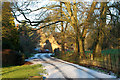
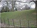
2
Staverton-Well Lane
A leafy lane which meanders steeply down through the wood smoke towards the footpath to Flecknoe.
Image: © Ian Rob
Taken: 27 Feb 2009
0.06 miles
4
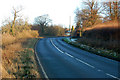
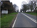
A425 looking east up the hill into Staverton
Image: © Andy F
Taken: 25 Dec 2009
0.09 miles
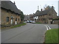
5
Staverton-The Woodlands
A mall collection of cottages set back from the A425.
Image: © Ian Rob
Taken: 27 Feb 2009
0.10 miles
6
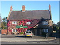
Staverton
Countryman Pub at junction with A425 and road to Catesby
Image: © Ian Rob
Taken: 20 Oct 2005
0.10 miles
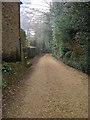
7
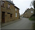
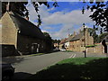
Staverton-Glebe Lane
A quiet village street.
Image: © Ian Rob
Taken: 27 Feb 2009
0.11 miles
10
Staverton, Northants - View N along Manor Rd
Image: © Colin Park
Taken: 3 Oct 2014
0.12 miles