IMAGES TAKEN NEAR TO
Catesby Road, DAVENTRY, NN11 6JP
Introduction
This page details the photographs taken nearby to Catesby Road, NN11 6JP by members of the Geograph project.
The Geograph project started in 2005 with the aim of publishing, organising and preserving representative images for every square kilometre of Great Britain, Ireland and the Isle of Man.

There are currently over 7.5m images from over14,400 individuals and you can help contribute to the project by visiting https://www.geograph.org.uk
Image Map
Images are licensed for reuse under creativecommons.org/licenses/by-sa/2.0
Notes
- Clicking on the map will re-center to the selected point.
- The higher the marker number, the further away the image location is from the centre of the postcode.
Image Listing (38 Images Found)
Images are licensed for reuse under creativecommons.org/licenses/by-sa/2.0
Image
Details
Distance
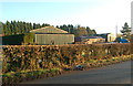
2
Transformer and sheds at Greenacres, Staverton
Image: © Andy F
Taken: 25 Dec 2009
0.03 miles
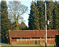
5
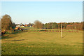
Looking north towards Greenacres near Staverton
Image: © Andy F
Taken: 25 Dec 2009
0.05 miles
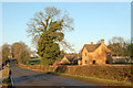
7
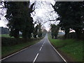
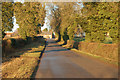
Road heading south from Staverton
Towards Upper Catesby.
Image: © JThomas
Taken: 28 Mar 2014
0.08 miles
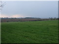
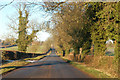
9
North along Hellidon Road to Staverton crossroads
Image: © Andy F
Taken: 25 Dec 2009
0.11 miles
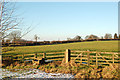
10
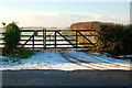
Entrance to Bates Farm, Hellidon Road, Staverton
Image: © Andy F
Taken: 25 Dec 2009
0.15 miles