IMAGES TAKEN NEAR TO
Farebrother Close, DAVENTRY, NN11 6FB
Introduction
This page details the photographs taken nearby to Farebrother Close, NN11 6FB by members of the Geograph project.
The Geograph project started in 2005 with the aim of publishing, organising and preserving representative images for every square kilometre of Great Britain, Ireland and the Isle of Man.

There are currently over 7.5m images from over14,400 individuals and you can help contribute to the project by visiting https://www.geograph.org.uk
Image Map
Images are licensed for reuse under creativecommons.org/licenses/by-sa/2.0
Notes
- Clicking on the map will re-center to the selected point.
- The higher the marker number, the further away the image location is from the centre of the postcode.
Image Listing (84 Images Found)
Images are licensed for reuse under creativecommons.org/licenses/by-sa/2.0
Image
Details
Distance
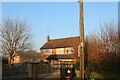
1
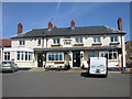
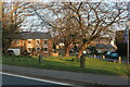
Byfield-The Cross Tree
The only pub in the Village.
Image: © Ian Rob
Taken: 15 Aug 2008
0.02 miles
2
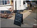
Byfield-The Cross Tree
The pub looks particularly cross at this point.
Image: © Ian Rob
Taken: 15 Aug 2008
0.02 miles
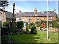
3
Byfield-Bell Lane
At the corner of Banbury Lane.
Image: © Ian Rob
Taken: 15 Aug 2008
0.03 miles
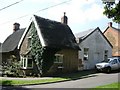
6
Byfield-Banbury Lane
Cottages in Banbury Lane.
Image: © Ian Rob
Taken: 15 Aug 2008
0.07 miles
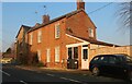
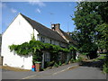
7
Village stores and cottages, Byfield
On the main Banbury to Daventry Road.
Image: © Andrew Smith
Taken: 26 Mar 2006
0.07 miles
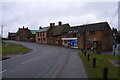
8
Byfield Village Club
Next to the old Chapel.
Image: © Ian Rob
Taken: 15 Aug 2008
0.07 miles
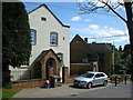
10
Byfield War Memorial
At the junction of High Street and Banbury Lane.
Image: © Ian Rob
Taken: 15 Aug 2008
0.08 miles