IMAGES TAKEN NEAR TO
Church Road, DAVENTRY, NN11 6DL
Introduction
This page details the photographs taken nearby to Church Road, NN11 6DL by members of the Geograph project.
The Geograph project started in 2005 with the aim of publishing, organising and preserving representative images for every square kilometre of Great Britain, Ireland and the Isle of Man.

There are currently over 7.5m images from over14,400 individuals and you can help contribute to the project by visiting https://www.geograph.org.uk
Image Map (Loading...)


Getting Data...Please wait
Leaflet Map data © OpenStreetMap
Images are licensed for reuse under creativecommons.org/licenses/by-sa/2.0
Notes
- Clicking on the map will re-center to the selected point.
- The higher the marker number, the further away the image location is from the centre of the postcode.
Image Listing (13 Images Found)
Images are licensed for reuse under creativecommons.org/licenses/by-sa/2.0
Image
Details
Distance
1
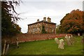
Upper Boddington-The Old Rectory
A close up view from the churchyard.
Image: © Ian Rob
Taken: 16 Oct 2014
0.04 miles
2
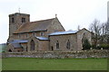
St John the Baptist's, Upper Boddington
Image: © Andrew Smith
Taken: 26 Mar 2006
0.04 miles
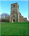
3
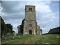
Upper Boddington Church
Saint John the Baptist.
Image: © Ian Rob
Taken: 4 Jun 2009
0.04 miles
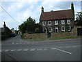
4
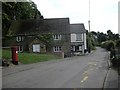
Upper Boddington Post office.
The post office and local store in School Street.
Image: © Ian Rob
Taken: 4 Jun 2009
0.05 miles
7
Upper Boddington-Welsh Road
Looking west from Welsh Road towards the village.Saint John the Baptist church tower can be seen.
Image: © Ian Rob
Taken: 29 Jan 2010
0.08 miles
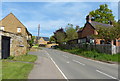
8
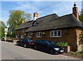
Upper Boddington-The Manor House
On the corner of Warwick Road and Frog Lane.
Image: © Ian Rob
Taken: 4 Jun 2009
0.10 miles
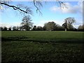
10
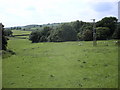
Upper Boddington Farmland
Looking west from close to the school.
Image: © Ian Rob
Taken: 4 Jun 2009
0.12 miles