IMAGES TAKEN NEAR TO
NN11 4WA
Introduction
This page details the photographs taken nearby to NN11 4WA by members of the Geograph project.
The Geograph project started in 2005 with the aim of publishing, organising and preserving representative images for every square kilometre of Great Britain, Ireland and the Isle of Man.

There are currently over 7.5m images from over14,400 individuals and you can help contribute to the project by visiting https://www.geograph.org.uk
Image Map
Images are licensed for reuse under creativecommons.org/licenses/by-sa/2.0
Notes
- Clicking on the map will re-center to the selected point.
- The higher the marker number, the further away the image location is from the centre of the postcode.
Image Listing (15 Images Found)
Images are licensed for reuse under creativecommons.org/licenses/by-sa/2.0
Image
Details
Distance
3
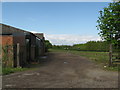
Farm buildings, Old Staverton Road, Daventry
Image: © Hazel Nicholson
Taken: 3 May 2010
0.11 miles
4
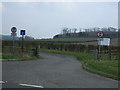
Daventry
Looking south uphill to Stepnell Spinney from lane which leads to Drayton Lodge.
Image: © Ian Rob
Taken: 8 Dec 2005
0.12 miles
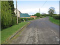
7
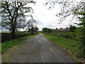
Old Staverton Road, Daventry
This part of Staverton Road was truncated when the Daventry bypass was built. This stub was retained for access to Drayton Lodge. Old road markings and where the cat's eyes were removed can be seen on the full size version.
Image: © Hazel Nicholson
Taken: 3 May 2010
0.16 miles
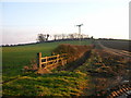
8
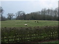
Grazing near The Tollgate
North of the A425.
Image: © JThomas
Taken: 28 Mar 2014
0.16 miles
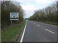
10
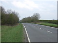
A45 from footbridge above, Daventry
Image: © Hazel Nicholson
Taken: 3 May 2010
0.19 miles