IMAGES TAKEN NEAR TO
Borough Hill, DAVENTRY, NN11 4NB
Introduction
This page details the photographs taken nearby to Borough Hill, NN11 4NB by members of the Geograph project.
The Geograph project started in 2005 with the aim of publishing, organising and preserving representative images for every square kilometre of Great Britain, Ireland and the Isle of Man.

There are currently over 7.5m images from over14,400 individuals and you can help contribute to the project by visiting https://www.geograph.org.uk
Image Map
Images are licensed for reuse under creativecommons.org/licenses/by-sa/2.0
Notes
- Clicking on the map will re-center to the selected point.
- The higher the marker number, the further away the image location is from the centre of the postcode.
Image Listing (2 Images Found)
Images are licensed for reuse under creativecommons.org/licenses/by-sa/2.0
Image
Details
Distance
1
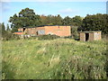
Daventry-Borough Hill
Derelict buildings at the north end of the disused radio station.
Image: © Ian Rob
Taken: 18 Oct 2009
0.02 miles
2
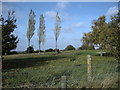
Daventry Golf Club
An elevated section of the course at the top of Borough Hill.
Image: © Ian Rob
Taken: 18 Oct 2009
0.12 miles