IMAGES TAKEN NEAR TO
Spring Close, DAVENTRY, NN11 4HG
Introduction
This page details the photographs taken nearby to Spring Close, NN11 4HG by members of the Geograph project.
The Geograph project started in 2005 with the aim of publishing, organising and preserving representative images for every square kilometre of Great Britain, Ireland and the Isle of Man.

There are currently over 7.5m images from over14,400 individuals and you can help contribute to the project by visiting https://www.geograph.org.uk
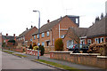
Image Map
Images are licensed for reuse under creativecommons.org/licenses/by-sa/2.0
Notes
- Clicking on the map will re-center to the selected point.
- The higher the marker number, the further away the image location is from the centre of the postcode.
Image Listing (76 Images Found)
Images are licensed for reuse under creativecommons.org/licenses/by-sa/2.0
Image
Details
Distance
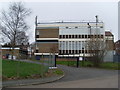
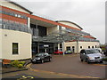
1

Daventry-Danetre Hospital
The new hospital building.
Image: © Ian Rob
Taken: 12 Feb 2010
0.08 miles
4
Daventry Telephone Exchange (2)
Taken from The Slade, this is a rear view of the TE showing a BT warning notice on the gate and mobile phone aerials on the roof. Looking at it, one could be forgiven for thinking that it was a modern hospital instead of a TE.
Image: © David Hillas
Taken: 7 Mar 2009
0.12 miles
5
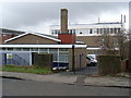
Daventry Telephone Exchange (1)
Situated in Badby Road, this TE dates from 1960, replacing the former Manual TE. Besides Daventry, this TE also serves Badby, Newnham, Norton, Staverton and Welton nearby. Its postcode is NN11 4AP.
Image: © David Hillas
Taken: 20 Mar 2010
0.13 miles
6
Daventry: Park Leys and Ashworth Street
This photograph is positioned using Where's The Path ('OS=Hybrid' option). See http://wtp2.appspot.com/wheresthepath.htm
Image: © In Depth
Taken: 22 Mar 2010
0.13 miles
7
Daventry: Ashworth Street
This photograph is positioned using Where's The Path ('OS=Hybrid' option). See http://wtp2.appspot.com/wheresthepath.htm
Image: © In Depth
Taken: 22 Mar 2010
0.13 miles
8
Daventry: Ashworth Street and Park Leys
This photograph is positioned using Where's The Path ('OS=Hybrid' option). See http://wtp2.appspot.com/wheresthepath.htm
Image: © In Depth
Taken: 22 Mar 2010
0.13 miles
10
Daventry: The Pasture
This photograph is positioned using Where's The Path ('OS=Hybrid' option). See http://wtp2.appspot.com/wheresthepath.htm
Image: © In Depth
Taken: 22 Mar 2010
0.14 miles