IMAGES TAKEN NEAR TO
Abbot Close, DAVENTRY, NN11 4EW
Introduction
This page details the photographs taken nearby to Abbot Close, NN11 4EW by members of the Geograph project.
The Geograph project started in 2005 with the aim of publishing, organising and preserving representative images for every square kilometre of Great Britain, Ireland and the Isle of Man.

There are currently over 7.5m images from over14,400 individuals and you can help contribute to the project by visiting https://www.geograph.org.uk
Image Map (Loading...)


Getting Data...Please wait
Leaflet Map data © OpenStreetMap
Images are licensed for reuse under creativecommons.org/licenses/by-sa/2.0
Notes
- Clicking on the map will re-center to the selected point.
- The higher the marker number, the further away the image location is from the centre of the postcode.
Image Listing (81 Images Found)
Images are licensed for reuse under creativecommons.org/licenses/by-sa/2.0
Image
Details
Distance
1
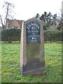
Old Milestone by the B4038, London Road, Daventry
Metal plate attached to stone post by the B4038, in parish of DAVENTRY (DAVENTRY District), North of The Slade junction, on open grass verge, on West side of road. Tarver iron casting, erected by the Old Stratford to Dunchurch turnpike trust in the 19th century.
Inscription reads:-
LONDON
71
DAVENTRY
½
TOWCESTER
11½
MILES
Plate Maker:
TARVER
DAVENTRY FOUNDRY.
Carved benchmark on lower face.
Grade II listed.
List Entry Number: 1470348 https://historicengland.org.uk/listing/the-list/list-entry/1470348
Milestone Society National ID: NR_LH71.
Image: © J Higgins
Taken: 1 Oct 2005
0.07 miles
2
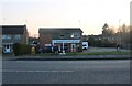
John Food and Wine on London Road, Daventry
A few years ago the sign said John News and Booze.
Image: © David Howard
Taken: 20 Mar 2022
0.09 miles
3
Daventry: St Augustin Way
This photograph is positioned using Where's The Path ('OS=Hybrid' option). See http://wtp2.appspot.com/wheresthepath.htm
Image: © In Depth
Taken: 28 Mar 2010
0.13 miles
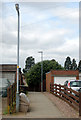
4

Daventry: St Augustin Way
This photograph is positioned using Where's The Path ('OS=Hybrid' option). See http://wtp2.appspot.com/wheresthepath.htm
Image: © In Depth
Taken: 28 Mar 2010
0.13 miles
5
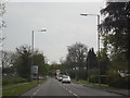
B4038 London Road, Daventry
The B4038 London Road facing southwest towards the Shell petrol station at the Marches industrial estate and on the way towards Weedon (A45).
Image: © Jareth W
Taken: 5 May 2014
0.13 miles
7
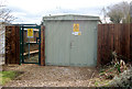
Daventry: substation in St Augustin Way
This photograph is positioned using Where's The Path ('OS=Hybrid' option). See http://wtp2.appspot.com/wheresthepath.htm
Image: © In Depth
Taken: 28 Mar 2010
0.14 miles
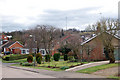
8
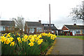
Daventry: daffodils in Priory Close
This photograph is positioned using Where's The Path ('OS=Hybrid' option). See http://wtp2.appspot.com/wheresthepath.htm
Image: © In Depth
Taken: 28 Mar 2010
0.14 miles
9
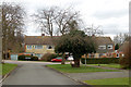
Daventry: Priory Close and St Augustine Way
This photograph is positioned using Where's The Path ('OS=Hybrid' option). See http://wtp2.appspot.com/wheresthepath.htm
Image: © In Depth
Taken: 28 Mar 2010
0.14 miles
10
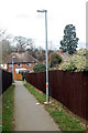
Daventry: path from St Augustin Way to The Maples
This photograph is positioned using Where's The Path ('OS=Hybrid' option). See http://wtp2.appspot.com/wheresthepath.htm
Image: © In Depth
Taken: 28 Mar 2010
0.14 miles