IMAGES TAKEN NEAR TO
Manitoba Way, DAVENTRY, NN11 3PT
Introduction
This page details the photographs taken nearby to Manitoba Way, NN11 3PT by members of the Geograph project.
The Geograph project started in 2005 with the aim of publishing, organising and preserving representative images for every square kilometre of Great Britain, Ireland and the Isle of Man.

There are currently over 7.5m images from over14,400 individuals and you can help contribute to the project by visiting https://www.geograph.org.uk
Image Map
Images are licensed for reuse under creativecommons.org/licenses/by-sa/2.0
Notes
- Clicking on the map will re-center to the selected point.
- The higher the marker number, the further away the image location is from the centre of the postcode.
Image Listing (12 Images Found)
Images are licensed for reuse under creativecommons.org/licenses/by-sa/2.0
Image
Details
Distance
1
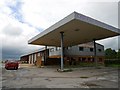
Eydon-Coach Station
The Geoff Amos Coach Station is now empty and the business appears to be no longer operating.
Image: © Ian Rob
Taken: 7 Jul 2012
0.07 miles
2
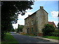
Eydon-Lime Avenue
Three storey house stands alone.
Image: © Ian Rob
Taken: 15 Aug 2008
0.13 miles
3
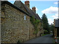
Eydon -Partridge Lane
A narrow lane linking Lime Avenue with High Street.
Image: © Ian Rob
Taken: 15 Aug 2008
0.15 miles
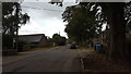
6
Eydon-High Street
At the junction with Moreton Road.
Image: © Ian Rob
Taken: 15 Aug 2008
0.19 miles
7
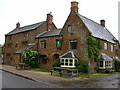
In Eydon village
Houses in Eydon village.
Image: © Peter Mackenzie
Taken: 21 Sep 2018
0.19 miles
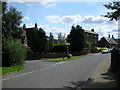
8
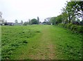
Bridleway into Eydon
From the west a bridleway approaches Eydon through this pasture.
Image: © Graham Horn
Taken: 27 Apr 2007
0.22 miles
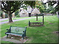
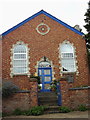
9
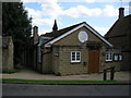
Eydon-Village Hall
Doctors lane runs to the side of the building.
Image: © Ian Rob
Taken: 15 Aug 2008
0.23 miles