IMAGES TAKEN NEAR TO
Badby, DAVENTRY, NN11 3DA
Introduction
This page details the photographs taken nearby to NN11 3DA by members of the Geograph project.
The Geograph project started in 2005 with the aim of publishing, organising and preserving representative images for every square kilometre of Great Britain, Ireland and the Isle of Man.

There are currently over 7.5m images from over14,400 individuals and you can help contribute to the project by visiting https://www.geograph.org.uk
Image Map
Images are licensed for reuse under creativecommons.org/licenses/by-sa/2.0
Notes
- Clicking on the map will re-center to the selected point.
- The higher the marker number, the further away the image location is from the centre of the postcode.
Image Listing (17 Images Found)
Images are licensed for reuse under creativecommons.org/licenses/by-sa/2.0
Image
Details
Distance
1
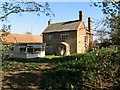
Staverton Lodge
Derelict house at Staverton Lodge.
Image: © Ian Rob
Taken: 15 Oct 2011
0.01 miles
2
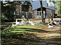
Staverton Lodge
Geese about to take a dip in a small pool at the farm.
Image: © Ian Rob
Taken: 15 Oct 2011
0.02 miles
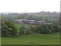
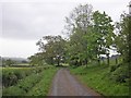
6
Upper Catesby
Country lane east of Staverton Lodge
Image: © Ian Rob
Taken: 8 Feb 2006
0.16 miles
7
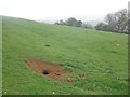
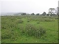
Badgers' sett, on the side of Arbury Hill
Image: © Roger Cornfoot
Taken: 24 May 2015
0.18 miles
8
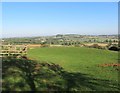
Arbury Hill View
Looking across SP5459, SP5460, SP5461 to Big Hill near Staverton.
Image: © Ian Rob
Taken: 15 Oct 2011
0.21 miles
9
The 'summit' of Arbury Hill
Highest point in Northamptonshire, at 738 feet above sea level.
Image: © Roger Cornfoot
Taken: 24 May 2015
0.21 miles
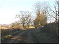
10
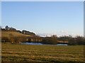
Pool near Arbury Hill
Looking towards Arbury Hill from the road to Upper Catesby.
Image: © Ian Rob
Taken: 8 Feb 2006
0.22 miles