IMAGES TAKEN NEAR TO
Bunkers Hill, DAVENTRY, NN11 3AW
Introduction
This page details the photographs taken nearby to Bunkers Hill, NN11 3AW by members of the Geograph project.
The Geograph project started in 2005 with the aim of publishing, organising and preserving representative images for every square kilometre of Great Britain, Ireland and the Isle of Man.

There are currently over 7.5m images from over14,400 individuals and you can help contribute to the project by visiting https://www.geograph.org.uk
Image Map
Images are licensed for reuse under creativecommons.org/licenses/by-sa/2.0
Notes
- Clicking on the map will re-center to the selected point.
- The higher the marker number, the further away the image location is from the centre of the postcode.
Image Listing (38 Images Found)
Images are licensed for reuse under creativecommons.org/licenses/by-sa/2.0
Image
Details
Distance
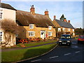
1
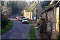
Bunkers Hill, Badby
Parts of Northamptonshire have all the charm of the Cotswolds but without the crowds or the eye-watering house prices. This scene, stripped of a few modern intrusions including the parked cars, has all the makings of a film set.
Image: © Stephen McKay
Taken: 5 Jan 2022
0.07 miles
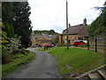
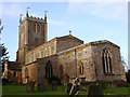
3
Church Hill, Badby
Church Hill leads down from St Mary's church to the junction with Bunkers Hill at the bottom.
Image: © Stephen McKay
Taken: 5 Jan 2022
0.09 miles
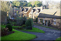
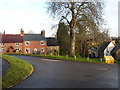
5

Badby-Church Hill
At the junction with Main Street and Bunkers Hill.
Image: © Ian Rob
Taken: 23 Aug 2008
0.11 miles
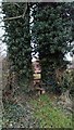
10
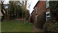
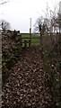
Path Emerges
Squeezed between two village property walls.
Image: © Stuart Shepherd
Taken: 9 Mar 2019
0.12 miles