IMAGES TAKEN NEAR TO
Newnham Road, DAVENTRY, NN11 3AA
Introduction
This page details the photographs taken nearby to Newnham Road, NN11 3AA by members of the Geograph project.
The Geograph project started in 2005 with the aim of publishing, organising and preserving representative images for every square kilometre of Great Britain, Ireland and the Isle of Man.

There are currently over 7.5m images from over14,400 individuals and you can help contribute to the project by visiting https://www.geograph.org.uk
Image Map
Images are licensed for reuse under creativecommons.org/licenses/by-sa/2.0
Notes
- Clicking on the map will re-center to the selected point.
- The higher the marker number, the further away the image location is from the centre of the postcode.
Image Listing (5 Images Found)
Images are licensed for reuse under creativecommons.org/licenses/by-sa/2.0
Image
Details
Distance
1
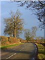
The B4037, Badby
The Newnham road in winter sunshine.
Image: © Andrew Smith
Taken: 5 Jan 2008
0.12 miles
2
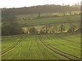
Farmland, Badby
A view across the upper Nene valley from the B4037 near The Meadows. A pleasant mixture of arable and pastoral farmland.
Image: © Andrew Smith
Taken: 5 Jan 2008
0.13 miles
3
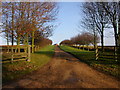
Badby
Lane leading to Meadows farm off Road to Newnham.
Image: © Ian Rob
Taken: 12 Jan 2006
0.14 miles
4
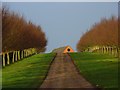
Driveway to Meadows Farm, Badby
The sunshine of a January afternoon highlights the colours of this avenue of young trees.
Image: © Andrew Smith
Taken: 5 Jan 2008
0.18 miles
5
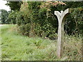
Spirit of the Valley
Wooden sculpture made in 2001 for Badby Youth Hostel as part of its celebration of the River Nene and Valley. The sculpture was moved to its current site along the Nene Way when the Youth Hostel closed in 2005.
Image: © Alan Kent
Taken: 21 Sep 2016
0.22 miles