IMAGES TAKEN NEAR TO
Brington Lane, DAVENTRY, NN11 2BL
Introduction
This page details the photographs taken nearby to Brington Lane, NN11 2BL by members of the Geograph project.
The Geograph project started in 2005 with the aim of publishing, organising and preserving representative images for every square kilometre of Great Britain, Ireland and the Isle of Man.

There are currently over 7.5m images from over14,400 individuals and you can help contribute to the project by visiting https://www.geograph.org.uk
Image Map
Images are licensed for reuse under creativecommons.org/licenses/by-sa/2.0
Notes
- Clicking on the map will re-center to the selected point.
- The higher the marker number, the further away the image location is from the centre of the postcode.
Image Listing (7 Images Found)
Images are licensed for reuse under creativecommons.org/licenses/by-sa/2.0
Image
Details
Distance
1
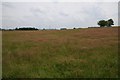
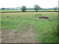
Farmland near Roughmoor Grounds
Farmland near Roughmoor Grounds on the eastern side of the village of Whilton.
Image: © Philip Halling
Taken: 17 Jul 2019
0.14 miles
2
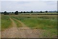
Farmland near Whilton
Arable farmland to the east of Whilton.
Image: © Philip Halling
Taken: 17 Jul 2019
0.18 miles
4
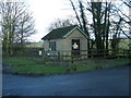
Whilton-Brington Road
Anglian water Pumping Station.
Image: © Ian Rob
Taken: 12 Feb 2010
0.19 miles
6
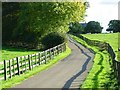
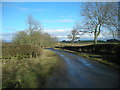
Lane to Roughmoor Grounds
Roughmoor Grounds is a farm off the Whilton - Great Brington road. It appears as 'Ringmore Grounds' on the 1940s map.
Image: © Stephen McKay
Taken: 24 Oct 2006
0.23 miles
7
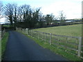
Whilton-Roughmoor Grounds
The lane leading away from the farm.
Image: © Ian Rob
Taken: 12 Feb 2010
0.23 miles