IMAGES TAKEN NEAR TO
Mallory Way, DAVENTRY, NN11 0UN
Introduction
This page details the photographs taken nearby to Mallory Way, NN11 0UN by members of the Geograph project.
The Geograph project started in 2005 with the aim of publishing, organising and preserving representative images for every square kilometre of Great Britain, Ireland and the Isle of Man.

There are currently over 7.5m images from over14,400 individuals and you can help contribute to the project by visiting https://www.geograph.org.uk
Image Map (Loading...)


Getting Data...Please wait
Leaflet Map data © OpenStreetMap
Images are licensed for reuse under creativecommons.org/licenses/by-sa/2.0
Notes
- Clicking on the map will re-center to the selected point.
- The higher the marker number, the further away the image location is from the centre of the postcode.
Image Listing (7 Images Found)
Images are licensed for reuse under creativecommons.org/licenses/by-sa/2.0
Image
Details
Distance
1
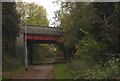
Daventry, dismantled railway path
This pathway is the dismantled railway line in Daventry via the Ashby Road bridge.
Image: © Jareth W
Taken: 31 Oct 2013
0.05 miles
2
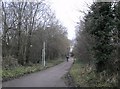
Daventry Foot and Cycle Path
A different kind of traffic is found on the dismantled Leamington-Weedon line as it winds through urban Daventry.
Image: © Ian Rob
Taken: 11 Jan 2011
0.06 miles
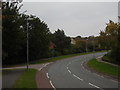
3
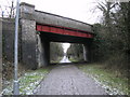
Daventry-Dismantled Leamington to Weedon Railway
The course of the railway is now a footpath through the town.Ashby Road crosses at this point.
Image: © Ian Rob
Taken: 12 Feb 2010
0.08 miles
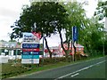
4
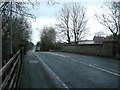
Daventry-Ashby Road
Ashby Road crosses the dismantled railway.
Image: © Ian Rob
Taken: 12 Feb 2010
0.08 miles
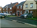
7
Shackleton Drive, Daventry
Looking Southeast down Shackleton Drive, Ashby Fields in Daventry towards the left hand turning for Franklin Way.
Image: © Jareth W
Taken: 3 Oct 2015
0.13 miles