IMAGES TAKEN NEAR TO
Wellingborough Road, RUSHDEN, NN10 9SZ
Introduction
This page details the photographs taken nearby to Wellingborough Road, NN10 9SZ by members of the Geograph project.
The Geograph project started in 2005 with the aim of publishing, organising and preserving representative images for every square kilometre of Great Britain, Ireland and the Isle of Man.

There are currently over 7.5m images from over14,400 individuals and you can help contribute to the project by visiting https://www.geograph.org.uk
Image Map
Images are licensed for reuse under creativecommons.org/licenses/by-sa/2.0
Notes
- Clicking on the map will re-center to the selected point.
- The higher the marker number, the further away the image location is from the centre of the postcode.
Image Listing (11 Images Found)
Images are licensed for reuse under creativecommons.org/licenses/by-sa/2.0
Image
Details
Distance
1
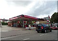
Service station on Wellingborough Road (A5001)
Petrol 159.9p.
Diesel 179.9p.
Image: © JThomas
Taken: 23 Sep 2022
0.01 miles
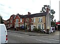
5
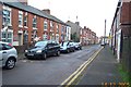
Rushden: Pemberton Street
Viewed looking north eastwards.
Image: © Nigel Cox
Taken: 14 Dec 2005
0.07 miles
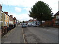
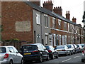
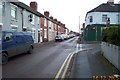
6
Rushden: Pytchley Road
Viewed looking westwards.
Image: © Nigel Cox
Taken: 14 Dec 2005
0.07 miles
8
Gordon Street, writing on the wall
Reads
Harrods
For Radio
And
Battery Service
Image: © Michael Trolove
Taken: 9 Jul 2011
0.12 miles
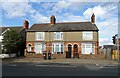
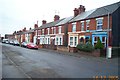
9
Rushden: Moor Road
Viewed looking south eastwards, with the spire of St Mary's Church just visible at the end of the street.
Image: © Nigel Cox
Taken: 14 Dec 2005
0.12 miles
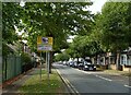
10
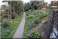
East Northamptonshire Greenway
On the course of the old railway
Image: © Philip Jeffrey
Taken: 20 Oct 2019
0.16 miles