IMAGES TAKEN NEAR TO
Coronation Avenue, RUSHDEN, NN10 9QP
Introduction
This page details the photographs taken nearby to Coronation Avenue, NN10 9QP by members of the Geograph project.
The Geograph project started in 2005 with the aim of publishing, organising and preserving representative images for every square kilometre of Great Britain, Ireland and the Isle of Man.

There are currently over 7.5m images from over14,400 individuals and you can help contribute to the project by visiting https://www.geograph.org.uk
Image Map (Loading...)


Getting Data...Please wait
Leaflet Map data © OpenStreetMap
Images are licensed for reuse under creativecommons.org/licenses/by-sa/2.0
Notes
- Clicking on the map will re-center to the selected point.
- The higher the marker number, the further away the image location is from the centre of the postcode.
Image Listing (7 Images Found)
Images are licensed for reuse under creativecommons.org/licenses/by-sa/2.0
Image
Details
Distance
7
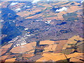
Rushden and Higham Ferrers
Looking along the Nene Valley, with the A45 running along the left side of the picture, and the A6 the main line feature running across.
Image: © M J Richardson
Taken: 11 Jul 2018
0.23 miles