IMAGES TAKEN NEAR TO
Church Lane, RUSHDEN, NN10 9LW
Introduction
This page details the photographs taken nearby to Church Lane, NN10 9LW by members of the Geograph project.
The Geograph project started in 2005 with the aim of publishing, organising and preserving representative images for every square kilometre of Great Britain, Ireland and the Isle of Man.

There are currently over 7.5m images from over14,400 individuals and you can help contribute to the project by visiting https://www.geograph.org.uk
Image Map (Loading...)


Getting Data...Please wait
Leaflet Map data © OpenStreetMap
Images are licensed for reuse under creativecommons.org/licenses/by-sa/2.0
Notes
- Clicking on the map will re-center to the selected point.
- The higher the marker number, the further away the image location is from the centre of the postcode.
Image Listing (12 Images Found)
Images are licensed for reuse under creativecommons.org/licenses/by-sa/2.0
Image
Details
Distance
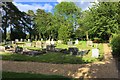
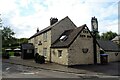
3
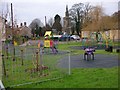
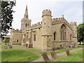
Wymington
A quiet corner of the village with children's play area and the village church in the background
Image: © Will Lovell
Taken: 20 Dec 2005
0.05 miles
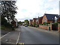
10
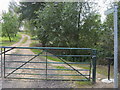
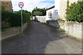
Footpath off Rushden Road
Footpath off Rushden Road Wymington
Image: © Shaun Ferguson
Taken: 4 Sep 2009
0.16 miles