IMAGES TAKEN NEAR TO
Grangeway, RUSHDEN, NN10 9EZ
Introduction
This page details the photographs taken nearby to Grangeway, NN10 9EZ by members of the Geograph project.
The Geograph project started in 2005 with the aim of publishing, organising and preserving representative images for every square kilometre of Great Britain, Ireland and the Isle of Man.

There are currently over 7.5m images from over14,400 individuals and you can help contribute to the project by visiting https://www.geograph.org.uk
Image Map
Images are licensed for reuse under creativecommons.org/licenses/by-sa/2.0
Notes
- Clicking on the map will re-center to the selected point.
- The higher the marker number, the further away the image location is from the centre of the postcode.
Image Listing (7 Images Found)
Images are licensed for reuse under creativecommons.org/licenses/by-sa/2.0
Image
Details
Distance
3
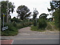
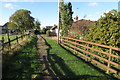
Footpath off Rushden Road
Footpath off Rushden Road by county boundary between Bedfordshire and Wymington to the left and Northamptonshire to the right
Image: © Shaun Ferguson
Taken: 4 Sep 2009
0.07 miles
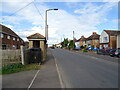
6
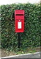
Elizabeth II postbox on Rushden Road
Postbox No. NN10 52.
Image: © JThomas
Taken: 23 Sep 2022
0.22 miles