IMAGES TAKEN NEAR TO
Queensway, RUSHDEN, NN10 8BU
Introduction
This page details the photographs taken nearby to Queensway, NN10 8BU by members of the Geograph project.
The Geograph project started in 2005 with the aim of publishing, organising and preserving representative images for every square kilometre of Great Britain, Ireland and the Isle of Man.

There are currently over 7.5m images from over14,400 individuals and you can help contribute to the project by visiting https://www.geograph.org.uk
Image Map (Loading...)


Getting Data...Please wait
Leaflet Map data © OpenStreetMap
Images are licensed for reuse under creativecommons.org/licenses/by-sa/2.0
Notes
- Clicking on the map will re-center to the selected point.
- The higher the marker number, the further away the image location is from the centre of the postcode.
Image Listing (106 Images Found)
Images are licensed for reuse under creativecommons.org/licenses/by-sa/2.0
Image
Details
Distance
4
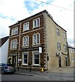
1 and 3 Wood Street, Higham Ferrers
A remodelled fifteenth century building https://historicengland.org.uk/listing/the-list/list-entry/1040365?section=official-list-entry
Image: © Jonathan Thacker
Taken: 16 Aug 2023
0.10 miles
8
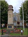
War memorial in Higham Ferrers
War memorial in the square in Higham Ferrers
Image: © Andrew Abbott
Taken: 20 Aug 2011
0.11 miles
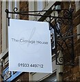
9
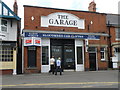
The Garage
High street garage for sale in Higham Ferrars. Complete with fuel pump and swing out arm for fuel delivery.
Image: © Michael Trolove
Taken: 9 Jul 2011
0.11 miles
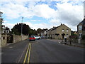
10
High Street, Higham Ferrers
Although nowadays effectively a northern extension of Rushden, Higham Ferrers is an ancient town. This view is looking along High Street with its independent retailers; this was once part of the A6 and A45 routes, both of which now by-pass the town.
Image: © Stephen McKay
Taken: 28 Jun 2008
0.12 miles