IMAGES TAKEN NEAR TO
Hayway, RUSHDEN, NN10 6AG
Introduction
This page details the photographs taken nearby to Hayway, NN10 6AG by members of the Geograph project.
The Geograph project started in 2005 with the aim of publishing, organising and preserving representative images for every square kilometre of Great Britain, Ireland and the Isle of Man.

There are currently over 7.5m images from over14,400 individuals and you can help contribute to the project by visiting https://www.geograph.org.uk
Image Map
Images are licensed for reuse under creativecommons.org/licenses/by-sa/2.0
Notes
- Clicking on the map will re-center to the selected point.
- The higher the marker number, the further away the image location is from the centre of the postcode.
Image Listing (8 Images Found)
Images are licensed for reuse under creativecommons.org/licenses/by-sa/2.0
Image
Details
Distance
1
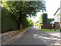
Oakfield
A private road off The Hayway.
Image: © Burgess Von Thunen
Taken: 20 May 2014
0.09 miles
2
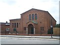
St Peter The Apostle Roman Catholic Church, Rushden
Image: © Geoff Pick
Taken: 1 Aug 2011
0.09 miles
3
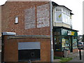
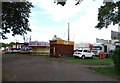
Food retailer on Washbrook road
Of greater interest are the two wall painted signs. The one on the left is slightly easier to read and is described thus
Hot & Cold
Luncheons
Served Daily
Parties Catered For
Bed & Breakfast
Fish Suppers Etc
Wireless Concerts
The one on the right is less easily read
The first line and possibly the name of the establishment is unclear followed by
Tea Rooms
Open Sundays
Hot & Cold
Anytime.
Image: © Michael Trolove
Taken: 9 Jul 2011
0.16 miles
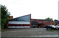
7
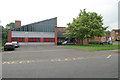
Rushden fire station
Rushden fire station, Washbrook Road, Rushden, Northamptonshire
Image: © Kevin Hale
Taken: 31 May 2008
0.23 miles