IMAGES TAKEN NEAR TO
Bernard Vann Close, RUSHDEN, NN10 0ZD
Introduction
This page details the photographs taken nearby to Bernard Vann Close, NN10 0ZD by members of the Geograph project.
The Geograph project started in 2005 with the aim of publishing, organising and preserving representative images for every square kilometre of Great Britain, Ireland and the Isle of Man.

There are currently over 7.5m images from over14,400 individuals and you can help contribute to the project by visiting https://www.geograph.org.uk
Image Map (9 Images)


Getting Data...Please wait
Leaflet Map data © OpenStreetMap
Images are licensed for reuse under creativecommons.org/licenses/by-sa/2.0
Notes
- Clicking on the map will re-center to the selected point.
- The higher the marker number, the further away the image location is from the centre of the postcode.
Image Listing (9 Images Found)
Images are licensed for reuse under creativecommons.org/licenses/by-sa/2.0
Image
Details
Distance
1
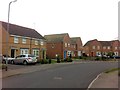
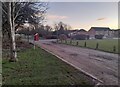
Sunningdale Drive
2000s houses in Manor Farm.
Image: © Burgess Von Thunen
Taken: 24 Apr 2013
0.10 miles

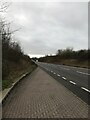
9
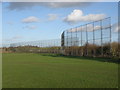
Perimeter fencing near Rushden
High fencing to prevent wayward rugby balls form bouncing down the A6 to Bedford at Rushden & Higham rugby club.
Image: © Michael Trolove
Taken: 3 Dec 2011
0.24 miles