IMAGES TAKEN NEAR TO
Queen Street, RUSHDEN, NN10 0AA
Introduction
This page details the photographs taken nearby to Queen Street, NN10 0AA by members of the Geograph project.
The Geograph project started in 2005 with the aim of publishing, organising and preserving representative images for every square kilometre of Great Britain, Ireland and the Isle of Man.

There are currently over 7.5m images from over14,400 individuals and you can help contribute to the project by visiting https://www.geograph.org.uk
Image Map (Loading...)


Getting Data...Please wait
Leaflet Map data © OpenStreetMap
Images are licensed for reuse under creativecommons.org/licenses/by-sa/2.0
Notes
- Clicking on the map will re-center to the selected point.
- The higher the marker number, the further away the image location is from the centre of the postcode.
Image Listing (31 Images Found)
Images are licensed for reuse under creativecommons.org/licenses/by-sa/2.0
Image
Details
Distance
1
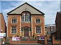
Independent Wesleyan Church, Rushden
Also known as 'The Church In The High Street'
Church web site: http://www.rushdenhighstreetchurch.co.uk/
Image: © Geoff Pick
Taken: 1 Aug 2011
0.04 miles
2
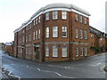
Former shoe factory in Rectory road
This was the Co-op boot and shoe factory. The link is about the in house fire brigade. http://www.rushdenheritage.co.uk/shoetrade/Co-op-firebrigade-PeterDanby.html
Image: © Michael Trolove
Taken: 9 Jul 2011
0.06 miles
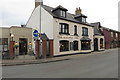
3
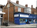
Blue Corner Cafe
High street cafe with some writing on the gable wall, see Image
Image: © Michael Trolove
Taken: 9 Jul 2011
0.06 miles
4
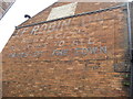
Writing on the wall of the Blue Corner Cafe
Reads. J.F.Robinson
Newsagent
Deliveries to all
Parts of the Town
and then someone built another shop next to it and the message was unseen.
Image: © Michael Trolove
Taken: 9 Jul 2011
0.06 miles
7
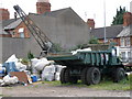
Euclid dump truck
Various bits of old plant and machinery in the stock yard of the Rushden Transport museum. Beyond the dump truck is most likely a Ransomes Rapier yard crane. The dump truck is usually displayed at the annual transport gathering organised by the museum at a suitably large field location nearby.
Image: © Michael Trolove
Taken: 9 Jul 2011
0.15 miles
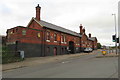
8
Station Approach, Rushden
The former railway station is seen top right. It is now occupied by the Historical Transport Society. The Queen Victoria Hotel (now closed) is on the left. It used to be hidden behind a railway bridge which was removed in the 1970's as a hazard to road traffic.
Image: © Will Lovell
Taken: 12 Dec 2005
0.16 miles
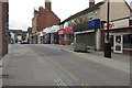
9
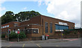
Former bus depot
Former town centre bus station now being used as a recycling centre.
Image: © Michael Trolove
Taken: 9 Jul 2011
0.17 miles
10
Rushden Historical Transport Society and Museum
Image: © Philip Jeffrey
Taken: 20 Oct 2019
0.17 miles