IMAGES TAKEN NEAR TO
Rockford Court, NOTTINGHAM, NG9 8LD
Introduction
This page details the photographs taken nearby to Rockford Court, NG9 8LD by members of the Geograph project.
The Geograph project started in 2005 with the aim of publishing, organising and preserving representative images for every square kilometre of Great Britain, Ireland and the Isle of Man.

There are currently over 7.5m images from over14,400 individuals and you can help contribute to the project by visiting https://www.geograph.org.uk
Image Map
Images are licensed for reuse under creativecommons.org/licenses/by-sa/2.0
Notes
- Clicking on the map will re-center to the selected point.
- The higher the marker number, the further away the image location is from the centre of the postcode.
Image Listing (8 Images Found)
Images are licensed for reuse under creativecommons.org/licenses/by-sa/2.0
Image
Details
Distance
1
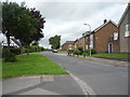
Braddon Avenue, Stapleford
Off Hickings Lane.
Image: © JThomas
Taken: 9 Jul 2016
0.10 miles
3
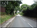
Hickings Lane (B6004), Stapleford
Heading north east.
Image: © JThomas
Taken: 9 Jul 2016
0.16 miles
4
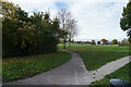
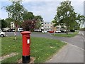
Playing fields
The playing fields are part of the Ilkeston Road Recreation Grounds.
Image: © Malcolm Neal
Taken: 18 Nov 2021
0.23 miles
5
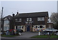
Man of Iron
Interesting name for a nondescript suburban pub.
Image: © Oxymoron
Taken: 29 Nov 2008
0.23 miles
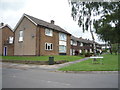
6
Matthews Court, Stapleford
A housing development from the late 1960s or early 1970s.
Image: © Andrew Abbott
Taken: 26 Apr 2020
0.24 miles
7
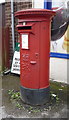
Elizabeth II postbox outside Dip Convenience Store, Stapleford
Postbox No. NG9 699.
See Image] for context.
Image: © JThomas
Taken: 9 Jul 2016
0.24 miles
8
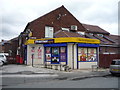
Dip Convenience Store, Stapleford
On Hickings Lane.
Showing position of Postbox No. NG9 699.
See Image] for postbox.
Image: © JThomas
Taken: 9 Jul 2016
0.24 miles