IMAGES TAKEN NEAR TO
Moorbridge Lane, NOTTINGHAM, NG9 8GT
Introduction
This page details the photographs taken nearby to Moorbridge Lane, NG9 8GT by members of the Geograph project.
The Geograph project started in 2005 with the aim of publishing, organising and preserving representative images for every square kilometre of Great Britain, Ireland and the Isle of Man.

There are currently over 7.5m images from over14,400 individuals and you can help contribute to the project by visiting https://www.geograph.org.uk
Image Map
Images are licensed for reuse under creativecommons.org/licenses/by-sa/2.0
Notes
- Clicking on the map will re-center to the selected point.
- The higher the marker number, the further away the image location is from the centre of the postcode.
Image Listing (44 Images Found)
Images are licensed for reuse under creativecommons.org/licenses/by-sa/2.0
Image
Details
Distance
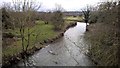
3
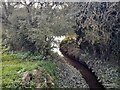
Boundary Brook flowing into the River Erewash
As the name suggests, Boundary Brook is a civil parish boundary.
Image: © Ian Calderwood
Taken: 17 Oct 2023
0.09 miles
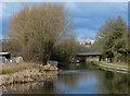
9
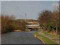
Two bridges over the Erewash Canal
The one in the background carries the M1
Image: © Tim Glover
Taken: 28 Jan 1999
0.15 miles
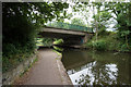
10
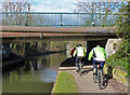
Cyclists passing under Stanton Gate Bridge No 13
Along the Erewash Canal.
Image: © Mat Fascione
Taken: 28 Feb 2016
0.15 miles