IMAGES TAKEN NEAR TO
New Road, NOTTINGHAM, NG9 8GS
Introduction
This page details the photographs taken nearby to New Road, NG9 8GS by members of the Geograph project.
The Geograph project started in 2005 with the aim of publishing, organising and preserving representative images for every square kilometre of Great Britain, Ireland and the Isle of Man.

There are currently over 7.5m images from over14,400 individuals and you can help contribute to the project by visiting https://www.geograph.org.uk
Image Map
Images are licensed for reuse under creativecommons.org/licenses/by-sa/2.0
Notes
- Clicking on the map will re-center to the selected point.
- The higher the marker number, the further away the image location is from the centre of the postcode.
Image Listing (9 Images Found)
Images are licensed for reuse under creativecommons.org/licenses/by-sa/2.0
Image
Details
Distance
4
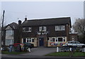
Man of Iron
Interesting name for a nondescript suburban pub.
Image: © Oxymoron
Taken: 29 Nov 2008
0.15 miles
6
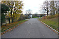
Pit Lane
This is Pit Lane looking towards the junction with Pasture Road the A6007.
Image: © Malcolm Neal
Taken: 18 Nov 2021
0.20 miles
8
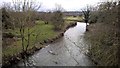
Boundary Brook flowing into the River Erewash
As the name suggests, Boundary Brook is a civil parish boundary.
Image: © Ian Calderwood
Taken: 17 Oct 2023
0.22 miles
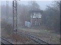
9
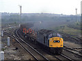
Northbound Steel Empties
A Class 40 heads around the curve at Stanton Gate with an empty steel train.
Image: © Peter Kazmierczak
Taken: Unknown
0.24 miles