IMAGES TAKEN NEAR TO
Hollis Close, NG9 8FW
Introduction
This page details the photographs taken nearby to Hollis Close, NG9 8FW by members of the Geograph project.
The Geograph project started in 2005 with the aim of publishing, organising and preserving representative images for every square kilometre of Great Britain, Ireland and the Isle of Man.

There are currently over 7.5m images from over14,400 individuals and you can help contribute to the project by visiting https://www.geograph.org.uk
Image Map
Images are licensed for reuse under creativecommons.org/licenses/by-sa/2.0
Notes
- Clicking on the map will re-center to the selected point.
- The higher the marker number, the further away the image location is from the centre of the postcode.
Image Listing (21 Images Found)
Images are licensed for reuse under creativecommons.org/licenses/by-sa/2.0
Image
Details
Distance
2
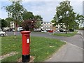
Matthews Court, Stapleford
A housing development from the late 1960s or early 1970s.
Image: © Andrew Abbott
Taken: 26 Apr 2020
0.08 miles
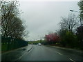
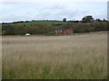
3
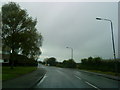
Field Farm housing development, Stapleford
The farm occupied the area beyond the lighting column.
Image: © Alan Murray-Rust
Taken: 9 Aug 2021
0.11 miles
4
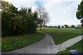
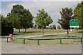
Playing fields
The playing fields are part of the Ilkeston Road Recreation Grounds.
Image: © Malcolm Neal
Taken: 18 Nov 2021
0.14 miles
8
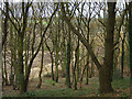
Stapleford Hill
Mature deciduous woodland on the northern slope.
Image: © Alan Murray-Rust
Taken: 25 Nov 2007
0.20 miles
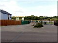
9
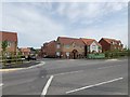
Field Farm Way
The new development of Field Farm by Westerman Homes.
Image: © Andrew Abbott
Taken: 26 Apr 2020
0.21 miles
10
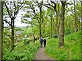
Walking in woods below Stapleford Hill
Image: © Chris Morgan
Taken: 12 May 2015
0.21 miles