IMAGES TAKEN NEAR TO
West Avenue, NOTTINGHAM, NG9 8DW
Introduction
This page details the photographs taken nearby to West Avenue, NG9 8DW by members of the Geograph project.
The Geograph project started in 2005 with the aim of publishing, organising and preserving representative images for every square kilometre of Great Britain, Ireland and the Isle of Man.

There are currently over 7.5m images from over14,400 individuals and you can help contribute to the project by visiting https://www.geograph.org.uk
Image Map
Images are licensed for reuse under creativecommons.org/licenses/by-sa/2.0
Notes
- Clicking on the map will re-center to the selected point.
- The higher the marker number, the further away the image location is from the centre of the postcode.
Image Listing (46 Images Found)
Images are licensed for reuse under creativecommons.org/licenses/by-sa/2.0
Image
Details
Distance
1
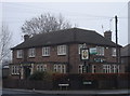
The Happy Man
Judging by the pub sign the eponymous hero may be Lord Nelson, perhaps having just won one of his famous victories.
Image: © Oxymoron
Taken: 29 Nov 2008
0.10 miles
2
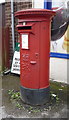
Elizabeth II postbox outside Dip Convenience Store, Stapleford
Postbox No. NG9 699.
See Image] for context.
Image: © JThomas
Taken: 9 Jul 2016
0.11 miles
3
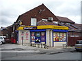
Dip Convenience Store, Stapleford
On Hickings Lane.
Showing position of Postbox No. NG9 699.
See Image] for postbox.
Image: © JThomas
Taken: 9 Jul 2016
0.11 miles
4
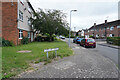
Copeland Avenue
Flats and maisonettes in Stapleford which is a Nottingham suburb.
Image: © Malcolm Neal
Taken: 24 Jun 2021
0.14 miles
5
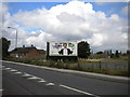
Vandalised hoarding, Nottingham Road, Stapleford
The advertisement on this hoarding facing onto Nottingham Road on the eastern approaches to Stapleford appears to have been quite imaginatively vandalised. However, this is likely to be part of the advertiser's current campaign.
Image: © Richard Vince
Taken: 7 Jul 2012
0.14 miles
6
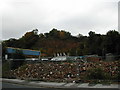
Sandstone cliffs at Stapleford
These cliffs are visible from the main road for a short stretch due to the demolition work in the foreground. The sandstone characterises the Bramcote and Stapleford areas, the most famous local example being the Hemlock Stone at Bramcote
Image: © Peter Shone
Taken: 13 Oct 2005
0.15 miles
8
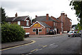
House at St John's Primary School
This house together with the one at the western corner of the site and the wall and gates linking them, are Listed Grade II separately from the school.
Image: © Alan Murray-Rust
Taken: 12 Jun 2018
0.16 miles
9
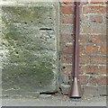
Bench mark, St John's Primary School
See http://www.geograph.org.uk/photo/5809212 for location.
Image: © Alan Murray-Rust
Taken: 12 Jun 2018
0.16 miles
10
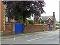
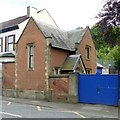
Boundary wall and lodges, St John's Primary School
The wall and its flanking lodges are Listed Grade II.
Image: © Alan Murray-Rust
Taken: 12 Jun 2018
0.17 miles