IMAGES TAKEN NEAR TO
Whiteley Close, NOTTINGHAM, NG9 8DT
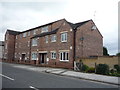
Introduction
This page details the photographs taken nearby to Whiteley Close, NG9 8DT by members of the Geograph project.
The Geograph project started in 2005 with the aim of publishing, organising and preserving representative images for every square kilometre of Great Britain, Ireland and the Isle of Man.

There are currently over 7.5m images from over14,400 individuals and you can help contribute to the project by visiting https://www.geograph.org.uk
Image Map
Images are licensed for reuse under creativecommons.org/licenses/by-sa/2.0
Notes
- Clicking on the map will re-center to the selected point.
- The higher the marker number, the further away the image location is from the centre of the postcode.
Image Listing (82 Images Found)
Images are licensed for reuse under creativecommons.org/licenses/by-sa/2.0
Image
Details
Distance
1
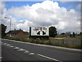
Vandalised hoarding, Nottingham Road, Stapleford
The advertisement on this hoarding facing onto Nottingham Road on the eastern approaches to Stapleford appears to have been quite imaginatively vandalised. However, this is likely to be part of the advertiser's current campaign.
Image: © Richard Vince
Taken: 7 Jul 2012
0.03 miles
2
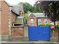
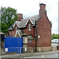
House at St John's Primary School
This house together with the one at the western corner of the site and the wall and gates linking them, are Listed Grade II separately from the school.
Image: © Alan Murray-Rust
Taken: 12 Jun 2018
0.04 miles
3
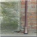
Bench mark, St John's Primary School
See http://www.geograph.org.uk/photo/5809212 for location.
Image: © Alan Murray-Rust
Taken: 12 Jun 2018
0.04 miles
4
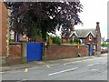
Boundary wall and lodges, St John's Primary School
The wall and its flanking lodges are Listed Grade II.
Image: © Alan Murray-Rust
Taken: 12 Jun 2018
0.04 miles
5
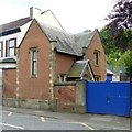
St John's Primary School
Looking past one of the lodges to the school in the distance. The school and the lodges date from 1836-7 and are separately Listed Grade II. There is a bench mark http://www.geograph.org.uk/photo/5809214 on the corner of the stone plinth of the lodge.
Image: © Alan Murray-Rust
Taken: 12 Jun 2018
0.04 miles
6
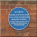
Blue plaque, St John's Primary School
See http://www.geograph.org.uk/photo/5809204 for location.
Image: © Alan Murray-Rust
Taken: 12 Jun 2018
0.05 miles
7
School house at St John's Primary School
Probably built as the schoolmaster's house. The house together with the smaller lodge at the eastern corner of the site and the wall and gates linking them, are Listed Grade II separately from the school.
Image: © Alan Murray-Rust
Taken: 12 Jun 2018
0.05 miles
8
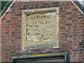
St John's Primary School (detail)
Inscribed panel in the central gable, now badly eroded. See http://www.geograph.org.uk/photo/5809204 for location.
Image: © Alan Murray-Rust
Taken: 12 Jun 2018
0.06 miles
9
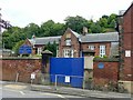
St John's Primary School
Founded as a National School in 1837 http://www.geograph.org.uk/photo/5809203 . The original buildings are largely unaltered. A limited view due to the high wall at the roadside. Listed Grade II.
Image: © Alan Murray-Rust
Taken: 12 Jun 2018
0.06 miles