IMAGES TAKEN NEAR TO
Cemetery Road, NOTTINGHAM, NG9 8AP
Introduction
This page details the photographs taken nearby to Cemetery Road, NG9 8AP by members of the Geograph project.
The Geograph project started in 2005 with the aim of publishing, organising and preserving representative images for every square kilometre of Great Britain, Ireland and the Isle of Man.

There are currently over 7.5m images from over14,400 individuals and you can help contribute to the project by visiting https://www.geograph.org.uk
Image Map
Images are licensed for reuse under creativecommons.org/licenses/by-sa/2.0
Notes
- Clicking on the map will re-center to the selected point.
- The higher the marker number, the further away the image location is from the centre of the postcode.
Image Listing (131 Images Found)
Images are licensed for reuse under creativecommons.org/licenses/by-sa/2.0
Image
Details
Distance
1
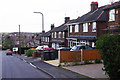
Cemetery Road, Stapleford
Semi detached houses line this short street that leads up to Stapleford Cemetery. As is so common nowadays, many of the front gardens have been converted into car parks.
Image: © Stephen McKay
Taken: 6 Dec 2015
0.02 miles
2
Stapleford Cemetery (1)
This is tucked away at the end of a quiet cul-de-sac about 0.5 mile from the bustle of the High Street, making for a very peaceful spot.
Image: © Oxymoron
Taken: 5 Aug 2008
0.03 miles
4
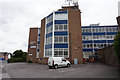
Cambridge House, Agrovista
Nottingham Road, Stapleford.
Image: © Ian S
Taken: 16 Jul 2016
0.04 miles
5
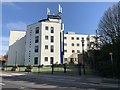
Cambridge House, Stapleford
A former office building purchased in 2016 and converted at a cost of £4.8m into apartments.
Image: © Andrew Abbott
Taken: 22 Mar 2020
0.05 miles
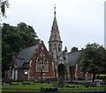
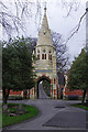
7
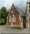
Stapleford Cemetery chapels
The northern chapel, originally for Church of England funerals.
The land for the cemetery and the chapels were the gift of Joseph Fearfield, an important lace manufacturer in the town. The chapels with their central spire in a mixture of Early English and Decorated Gothic styles were built in 1880 and are Listed Grade II.
Image: © Alan Murray-Rust
Taken: 12 Jun 2018
0.05 miles
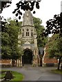
8
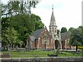
Stapleford Cemetery chapels
View from the north west.
The land for the cemetery and the chapels were the gift of Joseph Fearfield, an important lace manufacturer in the town. The chapels with their central spire in a mixture of Early English and Decorated Gothic styles were built in 1880 and are Listed Grade II.
Image: © Alan Murray-Rust
Taken: 12 Jun 2018
0.05 miles
9
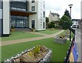
Manicured lawns at Cambridge House
Former office block now converted to apartments. The 'grass' is in fact plastic matting overlaid on what used to be a parking area.
Image: © Alan Murray-Rust
Taken: 12 Jun 2018
0.05 miles
10
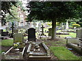
Stapleford Cemetery
The land for the town's cemetery was donated by local lace manufacturer Joseph Fearfield in 1880; his name is commemorated on a plaque above the archway. He also paid for the construction of the chapels. The cemetery is now operated by Broxtowe Borough Council. Local hero Walter Parker, who was awarded the Victoria Cross in the Gallipoli campaign of 1916, is buried here.
Image: © Stephen McKay
Taken: 6 Dec 2015
0.06 miles