IMAGES TAKEN NEAR TO
Holden Gardens, NOTTINGHAM, NG9 7GX
Introduction
This page details the photographs taken nearby to Holden Gardens, NG9 7GX by members of the Geograph project.
The Geograph project started in 2005 with the aim of publishing, organising and preserving representative images for every square kilometre of Great Britain, Ireland and the Isle of Man.

There are currently over 7.5m images from over14,400 individuals and you can help contribute to the project by visiting https://www.geograph.org.uk
Image Map
Images are licensed for reuse under creativecommons.org/licenses/by-sa/2.0
Notes
- Clicking on the map will re-center to the selected point.
- The higher the marker number, the further away the image location is from the centre of the postcode.
Image Listing (13 Images Found)
Images are licensed for reuse under creativecommons.org/licenses/by-sa/2.0
Image
Details
Distance
1
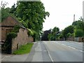
Toton Lane, Stapleford at Brookhill Street
There is a bench mark http://www.geograph.org.uk/photo/5808708 on the outbuilding on the left.
Image: © Alan Murray-Rust
Taken: 12 Jun 2018
0.08 miles
2
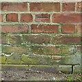
Bench mark, Toton Lane, Stapleford
See http://www.geograph.org.uk/photo/5808707 for location.
Image: © Alan Murray-Rust
Taken: 12 Jun 2018
0.08 miles
3
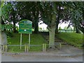
The entrance to Queen Elizabeth II Park, Stapleford
Now designated as a Queen Elizabeth II Field, and previously simply named Queen Elizabeth Park, possibly relating to the previous queen.
Image: © Alan Murray-Rust
Taken: 12 Jun 2018
0.13 miles
4

Bench mark, Fairfield Academy
On the end of the kitchen block.
Image: © Alan Murray-Rust
Taken: 12 Jun 2018
0.17 miles
5

Bench mark, 176 Brookhill Street, Stapleford
See http://www.geograph.org.uk/photo/5808706 for location.
Image: © Alan Murray-Rust
Taken: 12 Jun 2018
0.18 miles
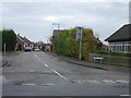
6
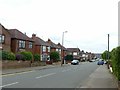
Brookhill Street, Stapleford
Looking west at Myrtle Avenue.
There is a bench mark http://www.geograph.org.uk/photo/5808705 on the far corner of the first house on the left.
Image: © Alan Murray-Rust
Taken: 12 Jun 2018
0.20 miles
7
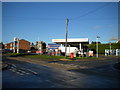
Filling station, Toton Lane, Stapleford
On the corner of Darkey Lane (right).
Image: © Richard Vince
Taken: 7 Nov 2015
0.20 miles
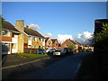
9
Darkey Lane
An ordinary suburban residential street. The name reappears on the bridleway to the east of the A52 Image, so it is obviously an old name.
Image: © Alan Murray-Rust
Taken: 25 Nov 2007
0.22 miles
10
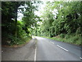
Toton Lane (B6003), Stapleford
Heading south east.
Image: © JThomas
Taken: 9 Jul 2016
0.23 miles