IMAGES TAKEN NEAR TO
Arnside, NOTTINGHAM, NG9 7EY
Introduction
This page details the photographs taken nearby to Arnside, NG9 7EY by members of the Geograph project.
The Geograph project started in 2005 with the aim of publishing, organising and preserving representative images for every square kilometre of Great Britain, Ireland and the Isle of Man.

There are currently over 7.5m images from over14,400 individuals and you can help contribute to the project by visiting https://www.geograph.org.uk
Image Map
Images are licensed for reuse under creativecommons.org/licenses/by-sa/2.0
Notes
- Clicking on the map will re-center to the selected point.
- The higher the marker number, the further away the image location is from the centre of the postcode.
Image Listing (17 Images Found)
Images are licensed for reuse under creativecommons.org/licenses/by-sa/2.0
Image
Details
Distance
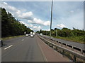
1
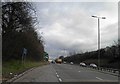
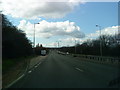
Lay-by on the A52 near the M1 junction 25
Image: © Steve Fareham
Taken: 12 Mar 2013
0.08 miles
2
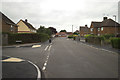
New Eaton Road junction with Wellspring Dale
Newly installed kerbs and pavements.
Image: © Mark Anderson
Taken: 28 Jul 2017
0.12 miles
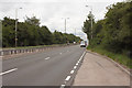
4
Brian Clough Way
Traffic on the Derby to Nottingham road, taken by a passenger with his arm out the window.
Image: © Bob Harvey
Taken: 17 Jul 2014
0.18 miles
8
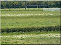
School playing fields across farmers fields
Image: © Andy Jamieson
Taken: 31 May 2009
0.22 miles
9
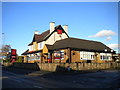
The Magpie, Toton Lane, Stapleford
A somewhat plain suburban pub.
Image: © Richard Vince
Taken: 7 Nov 2015
0.22 miles
10
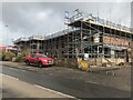
New building on the site of The Magpie
An apartment block it would seem.
Note the stone boundary wall has not been removed. Image
Image: © David Lally
Taken: 28 Feb 2023
0.22 miles