IMAGES TAKEN NEAR TO
Stirling Gardens, NOTTINGHAM, NG9 6NJ
Introduction
This page details the photographs taken nearby to Stirling Gardens, NG9 6NJ by members of the Geograph project.
The Geograph project started in 2005 with the aim of publishing, organising and preserving representative images for every square kilometre of Great Britain, Ireland and the Isle of Man.

There are currently over 7.5m images from over14,400 individuals and you can help contribute to the project by visiting https://www.geograph.org.uk
Image Map (Loading...)


Getting Data...Please wait
Leaflet Map data © OpenStreetMap
Images are licensed for reuse under creativecommons.org/licenses/by-sa/2.0
Notes
- Clicking on the map will re-center to the selected point.
- The higher the marker number, the further away the image location is from the centre of the postcode.
Image Listing (16 Images Found)
Images are licensed for reuse under creativecommons.org/licenses/by-sa/2.0
Image
Details
Distance
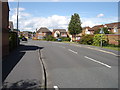
1
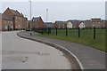
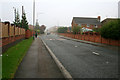
Woodward Avenue - Chilwell
A large section of the Chetwynd Barracks was sold off a few years ago. This now makes up the Chetwynd business park Image and this large mixed housing development.
Image: © David Lally
Taken: 3 Jan 2008
0.16 miles
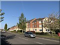
2
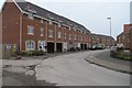
Woodward Avenue - Chilwell
A large section of the Chetwynd Barracks was sold off a few years ago. This now makes up the Chetwynd business park Image and this large mixed housing development.
Image: © David Lally
Taken: 3 Jan 2008
0.17 miles
3
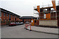
Chetwynd Business Park
The park currently consists of units under construction, completed empty units and occupied units.
Image: © David Lally
Taken: 3 Jan 2008
0.18 miles
4

Hover time
Chinooks Practising Hovering - they didn't land - at a sports field at Chetwynd Barracks.
Image: © Andy Jamieson
Taken: Unknown
0.18 miles
6
Newhall Drive, Chilwell
Typical of the roads on this new estate south of Chetwynd barracks.
Image: © Oxymoron
Taken: 14 Aug 2008
0.20 miles
8
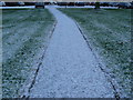
Virgin snow
Untrod till I walked on it to get to the office.
Image: © Andy Jamieson
Taken: 2 Dec 2008
0.22 miles
9
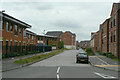
Shaw Road
Mixed residential and business development on the former Chilwell Ordnance Depot site.
Image: © Alan Murray-Rust
Taken: 24 Jun 2010
0.22 miles
10
Ranson Road
A road without addresses, I think. There are no properties on this road to the left are entrances to a car dealership and the car park of the West Gate shopping centre to the right Sherman Drive leads to a housing estate.
Image: © David Lally
Taken: 8 Oct 2010
0.23 miles