IMAGES TAKEN NEAR TO
Spinney Rise, NOTTINGHAM, NG9 6JN
Introduction
This page details the photographs taken nearby to Spinney Rise, NG9 6JN by members of the Geograph project.
The Geograph project started in 2005 with the aim of publishing, organising and preserving representative images for every square kilometre of Great Britain, Ireland and the Isle of Man.

There are currently over 7.5m images from over14,400 individuals and you can help contribute to the project by visiting https://www.geograph.org.uk
Image Map
Images are licensed for reuse under creativecommons.org/licenses/by-sa/2.0
Notes
- Clicking on the map will re-center to the selected point.
- The higher the marker number, the further away the image location is from the centre of the postcode.
Image Listing (44 Images Found)
Images are licensed for reuse under creativecommons.org/licenses/by-sa/2.0
Image
Details
Distance
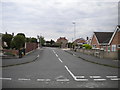
1
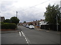
Seaburn Road, Toton
Seen from the junction with Cleveleys Road.
Image: © Richard Vince
Taken: 17 Aug 2015
0.07 miles
5
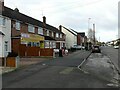
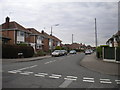
Woodstock Road, Toton
Typical post-WW2 housing estate, with the local shop. The bus stop enjoys, in 2023, just one early morning journey each weekday.
Image: © Alan Murray-Rust
Taken: 13 Jan 2023
0.13 miles
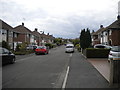
9
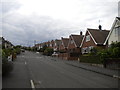
Darley Avenue
Leaving the barracks behind as I head for the A52 with this slight diversion into Darley Avenue which is part of a housing estate close to Toton sidings.
Image: © Malcolm Neal
Taken: 17 Jun 2021
0.18 miles