IMAGES TAKEN NEAR TO
Woodstock Road, NOTTINGHAM, NG9 6HW
Introduction
This page details the photographs taken nearby to Woodstock Road, NG9 6HW by members of the Geograph project.
The Geograph project started in 2005 with the aim of publishing, organising and preserving representative images for every square kilometre of Great Britain, Ireland and the Isle of Man.

There are currently over 7.5m images from over14,400 individuals and you can help contribute to the project by visiting https://www.geograph.org.uk
Image Map
Images are licensed for reuse under creativecommons.org/licenses/by-sa/2.0
Notes
- Clicking on the map will re-center to the selected point.
- The higher the marker number, the further away the image location is from the centre of the postcode.
Image Listing (28 Images Found)
Images are licensed for reuse under creativecommons.org/licenses/by-sa/2.0
Image
Details
Distance
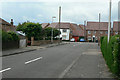
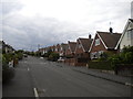
1
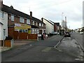
Woodstock Road, Toton
Typical post-WW2 housing estate, with the local shop. The bus stop enjoys, in 2023, just one early morning journey each weekday.
Image: © Alan Murray-Rust
Taken: 13 Jan 2023
0.05 miles
3
Seaburn Road, Toton
Seen from the junction with Cleveleys Road.
Image: © Richard Vince
Taken: 17 Aug 2015
0.11 miles
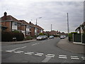
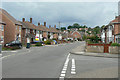
5
Broadstairs Road
Looking west towards Sandown Road. The housing in the background is recent infill development.
Image: © Alan Murray-Rust
Taken: 24 Jun 2010
0.14 miles
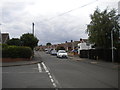
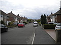
6
Sandown Road
The immediate group of roads here are named after lesser seaside resorts.
Image: © Alan Murray-Rust
Taken: 24 Jun 2010
0.15 miles
8
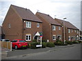
Chestnut Place, Toton
A small quantity of new houses at the south eastern end of Bispham Drive.
Image: © Richard Vince
Taken: 17 Aug 2015
0.15 miles
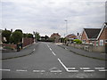
10
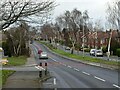
Stapleford Lane, Toton
Looking towards Stapleford near Woodstock Road. The housing was developed in the 1950s and 60s.
Image: © Alan Murray-Rust
Taken: 13 Jan 2023
0.17 miles