IMAGES TAKEN NEAR TO
Birkin Avenue, NOTTINGHAM, NG9 6ET
Introduction
This page details the photographs taken nearby to Birkin Avenue, NG9 6ET by members of the Geograph project.
The Geograph project started in 2005 with the aim of publishing, organising and preserving representative images for every square kilometre of Great Britain, Ireland and the Isle of Man.

There are currently over 7.5m images from over14,400 individuals and you can help contribute to the project by visiting https://www.geograph.org.uk
Image Map (Loading...)


Getting Data...Please wait
Leaflet Map data © OpenStreetMap
Images are licensed for reuse under creativecommons.org/licenses/by-sa/2.0
Notes
- Clicking on the map will re-center to the selected point.
- The higher the marker number, the further away the image location is from the centre of the postcode.
Image Listing (237 Images Found)
Images are licensed for reuse under creativecommons.org/licenses/by-sa/2.0
Image
Details
Distance
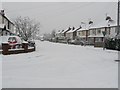
4
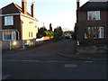
Inchwood Close Toton
Private road off Carrfield Avenue
Image: © Andy Jamieson
Taken: 10 Dec 2008
0.07 miles
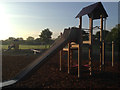
6
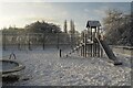
Snowy playground slide
In Toton Manor Park.
Image: © David Lally
Taken: 25 Jan 2021
0.09 miles
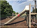
9
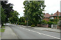
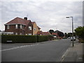
Stapleford Lane, Toton
This is historically the main road between Stapleford and Long Eaton. Toton developed in the inter- and post-war periods as a large dormitory suburb.
Image: © Alan Murray-Rust
Taken: 24 Jun 2010
0.10 miles