IMAGES TAKEN NEAR TO
Brailsford Way, NOTTINGHAM, NG9 6DH
Introduction
This page details the photographs taken nearby to Brailsford Way, NG9 6DH by members of the Geograph project.
The Geograph project started in 2005 with the aim of publishing, organising and preserving representative images for every square kilometre of Great Britain, Ireland and the Isle of Man.

There are currently over 7.5m images from over14,400 individuals and you can help contribute to the project by visiting https://www.geograph.org.uk
Image Map
Images are licensed for reuse under creativecommons.org/licenses/by-sa/2.0
Notes
- Clicking on the map will re-center to the selected point.
- The higher the marker number, the further away the image location is from the centre of the postcode.
Image Listing (134 Images Found)
Images are licensed for reuse under creativecommons.org/licenses/by-sa/2.0
Image
Details
Distance
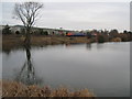
1
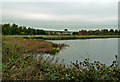
From Barton Lane
Looking over a pool on the edge of the Attenborough Nature Reserve on a disappointingly dull October day.
Image: © Mary and Angus Hogg
Taken: 18 Oct 2017
0.05 miles
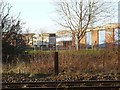
3
Attenborough Nature Reserve Path by the railway
Image: © Andy Jamieson
Taken: 18 Jan 2009
0.07 miles
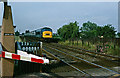
4

A train passing Church Pond
The Railway line runs along the edge of the Attenborough Nature Reserve. The area is currently seeing extensive Environment Agency flood protection work.
Image: © David Lally
Taken: 9 Apr 2010
0.08 miles
5
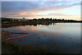
Church Pond at sunrise
Compare this with the scene before the start of the flood defence works Image
Image: © David Lally
Taken: 19 Oct 2010
0.09 miles
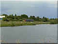
6
Church Pond with Train
The view is much more open than before http://www.geograph.org.uk/photo/763777, because work has started on the new flood defences which are to run alongside the tracks here. To date just the clearing of the scrub has been done.
Image: © David Lally
Taken: 17 Feb 2009
0.09 miles

8
Barton Lane Level Crossing
A class 45 locomotive and rake of air conditioned mark II coaches approach Barton Lane automatic half-barrier crossing to the west of Attenborough station. This was a standard formation on the Midland Main Line at the time of this 1978 image.
Image: © Stephen McKay
Taken: Unknown
0.10 miles
9
Train from Nottingham
Passing Attenborough Nature Reserve. Seen from Barton Lane across Church Pond
Image: © Alan Murray-Rust
Taken: 15 Jun 2009
0.10 miles
10
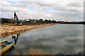
Flood protection work continues
By Church Pond, Attenborough. The bank now extends out to the orange marker seen in Image
Image: © David Lally
Taken: 16 Mar 2010
0.10 miles