IMAGES TAKEN NEAR TO
Barratt Lane, NOTTINGHAM, NG9 6AF
Introduction
This page details the photographs taken nearby to Barratt Lane, NG9 6AF by members of the Geograph project.
The Geograph project started in 2005 with the aim of publishing, organising and preserving representative images for every square kilometre of Great Britain, Ireland and the Isle of Man.

There are currently over 7.5m images from over14,400 individuals and you can help contribute to the project by visiting https://www.geograph.org.uk
Image Map
Images are licensed for reuse under creativecommons.org/licenses/by-sa/2.0
Notes
- Clicking on the map will re-center to the selected point.
- The higher the marker number, the further away the image location is from the centre of the postcode.
Image Listing (168 Images Found)
Images are licensed for reuse under creativecommons.org/licenses/by-sa/2.0
Image
Details
Distance
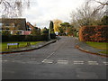
1
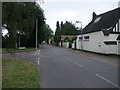
Cycle Route 6 on Barratt Lane
A quiet residential street between the main railway line and the very busy A6005
Image: © Tim Heaton
Taken: 2 Sep 2012
0.02 miles
2
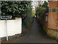
Footpath to the Railway and Attenborough Nature Reserve
Image: © Andy Jamieson
Taken: 23 Nov 2008
0.03 miles
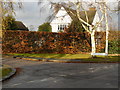
3
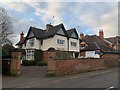
The Haven
15 Barratt Lane, Attenborough
Image: © Andrew Abbott
Taken: 2 Apr 2020
0.03 miles
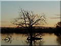
5

Sunset at Attenborough nature reserve
Facing West across the sailing club pond.
Image: © Peter Shone
Taken: 15 Dec 2001
0.04 miles
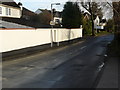
9
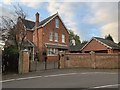
The Firs
19 Barratt Lane, Attenborough
Image: © Andrew Abbott
Taken: 2 Apr 2020
0.05 miles
10
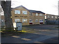
Labour Party office Attenborough
The Labour party having a laugh having this here as this is a solid Tory area
Image: © Andy Jamieson
Taken: 7 Dec 2008
0.05 miles