IMAGES TAKEN NEAR TO
Greenland Crescent, NOTTINGHAM, NG9 5LB
Introduction
This page details the photographs taken nearby to Greenland Crescent, NG9 5LB by members of the Geograph project.
The Geograph project started in 2005 with the aim of publishing, organising and preserving representative images for every square kilometre of Great Britain, Ireland and the Isle of Man.

There are currently over 7.5m images from over14,400 individuals and you can help contribute to the project by visiting https://www.geograph.org.uk
Image Map
Images are licensed for reuse under creativecommons.org/licenses/by-sa/2.0
Notes
- Clicking on the map will re-center to the selected point.
- The higher the marker number, the further away the image location is from the centre of the postcode.
Image Listing (32 Images Found)
Images are licensed for reuse under creativecommons.org/licenses/by-sa/2.0
Image
Details
Distance
1
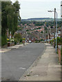
Oakdale Drive
Looking south. The spire of Attenborough Church Image can be seen in the distance.
Image: © Alan Murray-Rust
Taken: 6 Sep 2009
0.08 miles
2
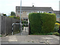
5 seconds or 5 minutes
About 5 seconds on foot to get from one end (Bolton Avenue) of this alley to the other (Oakdale Drive), but about 5 minutes by car. The distance by road is nearly 2 km.
Image: © Alan Murray-Rust
Taken: 6 Sep 2009
0.08 miles
4
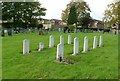
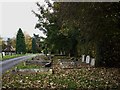
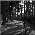
Commonwealth War Graves, Chilwell Cemetery
Given the closeness to the large Chilwell Ordnance Depot, a larger number might have been expected here. The dates of death range from 1941 to 2007, the latter being the one nearest the camera.
Image: © Alan Murray-Rust
Taken: 17 Oct 2016
0.08 miles
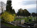
5
Chilwell Cemetery
This felt a particularly sad and desolate place on a very cold autumn afternoon.
Image: © Oxymoron
Taken: 30 Oct 2008
0.09 miles
6
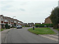
Northdown Drive
Roads on the south side of Field Lane were developed as private, not council, housing in the 1960s.
Image: © Alan Murray-Rust
Taken: 6 Sep 2009
0.10 miles
7
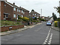
Redland Drive
1950s/60s housing development in Chilwell.
Image: © Alan Murray-Rust
Taken: 6 Sep 2009
0.13 miles
8
Penrhyn Crescent
Roads on the south side of Field Lane were developed as private, not council, housing in the 1960s.
Image: © Alan Murray-Rust
Taken: 6 Sep 2009
0.15 miles
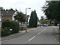
9
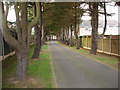
Road Leading to Chilwell Cemetery
The cemetery is tucked away behind houses, and can only be accessed via this single track road.
Image: © Oxymoron
Taken: 30 Oct 2008
0.16 miles
10
The drive to Chilwell Cemetery
Planted with a fine avenue of now mature larch trees.
Image: © Alan Murray-Rust
Taken: 17 Oct 2016
0.17 miles