IMAGES TAKEN NEAR TO
Crofton Close, NOTTINGHAM, NG9 5HX
Introduction
This page details the photographs taken nearby to Crofton Close, NG9 5HX by members of the Geograph project.
The Geograph project started in 2005 with the aim of publishing, organising and preserving representative images for every square kilometre of Great Britain, Ireland and the Isle of Man.

There are currently over 7.5m images from over14,400 individuals and you can help contribute to the project by visiting https://www.geograph.org.uk
Image Map
Images are licensed for reuse under creativecommons.org/licenses/by-sa/2.0
Notes
- Clicking on the map will re-center to the selected point.
- The higher the marker number, the further away the image location is from the centre of the postcode.
Image Listing (61 Images Found)
Images are licensed for reuse under creativecommons.org/licenses/by-sa/2.0
Image
Details
Distance
1
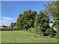
Footpaths on the playing fields
Between Attenborough and Chilwell
Image: © Andrew Abbott
Taken: 30 Apr 2020
0.07 miles
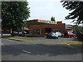

4
Petrol station development
This former petrol station has been a hand car wash as long as I can remember and possibly has not been a filling station for 15 - 20 years. The earliest Google Street View from '08 shows cars being washed! https://www.google.co.uk/maps/@52.9115006,-1.2341062,3a,75y,54.85h,86.13t/data=!3m6!1e1!3m4!1s9BVNXy7O60gy4dnx-SoP5g!2e0!7i13312!8i6656
Finally looks like housing is on the way.
Image: © David Lally
Taken: 22 Oct 2021
0.13 miles
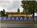
5
Chilwell Sixth Form School
Built as Chilwell Comprehensive School, the building on the left was opened as the Lower School and is Grade II listed. Listing number 1441692. Chilwell Lower School was built in 1975-1976 to the designs of Michael Tempest, directing architect, and Roger Bearsmore, project architect, at Nottinghamshire County Council. It was designed as the lower school component of a 9 form entry mixed comprehensive school catering for 540 pupils aged 11 to 13. Like the main comprehensive school which was built in 1970-1971, the Lower School was built in CLASP Mark V. The building of schools and other public buildings in Nottinghamshire after 1955 is closely tied up with CLASP – the Consortium of Local Authorities Special Programme – which was launched in 1957. The County Architect Donald Gibson devised a method of building schools using a lightweight prefabricated system that was economical and could withstand mining subsidence.
Image: © Andrew Abbott
Taken: 30 Apr 2020
0.13 miles
6
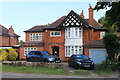
191 Bye Pass Road, Chilwell
Detached house.
Image: © Andrew Abbott
Taken: 24 May 2020
0.14 miles
8
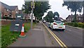
Google car on Bye Pass Road
Going to be famous!
Image: © David Lally
Taken: 20 Jun 2017
0.16 miles

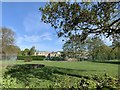
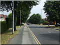
10

Nottingham Road at the junction with Attenborough Lane
Image: © Andrew Abbott
Taken: 15 Jun 2010
0.16 miles