IMAGES TAKEN NEAR TO
Highfield Road, NOTTINGHAM, NG9 5GP
Introduction
This page details the photographs taken nearby to Highfield Road, NG9 5GP by members of the Geograph project.
The Geograph project started in 2005 with the aim of publishing, organising and preserving representative images for every square kilometre of Great Britain, Ireland and the Isle of Man.

There are currently over 7.5m images from over14,400 individuals and you can help contribute to the project by visiting https://www.geograph.org.uk
Image Map
Images are licensed for reuse under creativecommons.org/licenses/by-sa/2.0
Notes
- Clicking on the map will re-center to the selected point.
- The higher the marker number, the further away the image location is from the centre of the postcode.
Image Listing (8 Images Found)
Images are licensed for reuse under creativecommons.org/licenses/by-sa/2.0
Image
Details
Distance
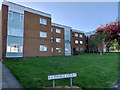
1
Airedale Court, Inham Nook Estate
This area to the west of Field Lane was the final part of the estate to be built. There is a bench mark http://www.geograph.org.uk/photo/5159546 on the gable end of the nearest house.
Image: © Alan Murray-Rust
Taken: 17 Oct 2016
0.17 miles
2
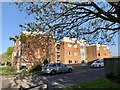
Airedale Court
Off Field Lane, Chilwell
Image: © Andrew Abbott
Taken: 21 Apr 2020
0.18 miles
3
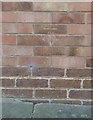
Bench mark, 1 Airedale Court, Inham Nook Estate
Unusually, the mark has been cut with the vertical stroke of the arrow right in the mortar joint. See http://www.geograph.org.uk/photo/5159550 for location.
Image: © Alan Murray-Rust
Taken: 17 Oct 2016
0.18 miles
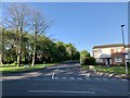
4
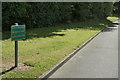
No tipping rubbish on the grass verge
Maybe it's OK to tip on the roadway?
Image: © Alan Murray-Rust
Taken: 21 Jun 2010
0.19 miles
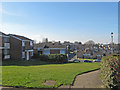
5
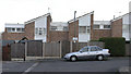
Airedale Court, Chilwell
Taken from Airedale Court car park, the houses front onto Field Lane.
Image: © David Lally
Taken: 12 Dec 2007
0.22 miles
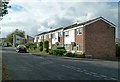
6
Rathvale Court
Off Field Lane, Chilwell
Image: © Andrew Abbott
Taken: 21 Apr 2020
0.22 miles