IMAGES TAKEN NEAR TO
Royal Mews, NOTTINGHAM, NG9 5FZ
Introduction
This page details the photographs taken nearby to Royal Mews, NG9 5FZ by members of the Geograph project.
The Geograph project started in 2005 with the aim of publishing, organising and preserving representative images for every square kilometre of Great Britain, Ireland and the Isle of Man.

There are currently over 7.5m images from over14,400 individuals and you can help contribute to the project by visiting https://www.geograph.org.uk
Image Map
Images are licensed for reuse under creativecommons.org/licenses/by-sa/2.0
Notes
- Clicking on the map will re-center to the selected point.
- The higher the marker number, the further away the image location is from the centre of the postcode.
Image Listing (22 Images Found)
Images are licensed for reuse under creativecommons.org/licenses/by-sa/2.0
Image
Details
Distance
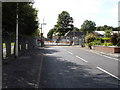
1
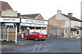
Depot Corner - Chilwell
The date stone (detail here Image) looks very out of place on this small shop which looks to date from the 1960s rather than the 1930s but a much larger building has left its shadow upon the neighbouring gable. The building in question was a shop belonging to the Long Eaton Co-op (information thanks to Patrick Oakes).
For why this is called Depot corner see Image
Image: © David Lally
Taken: 5 Dec 2007
0.07 miles
2
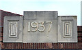
Art Deco Date - Depot Corner, Chilwell
This date stone seems very out of place in its current location Image
Image: © David Lally
Taken: 5 Dec 2007
0.08 miles
3
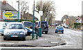
Depot Corner - Chilwell
At this corner High Road, Chilwell continues as Chetwynd Road, while the main traffic route turns left and becomes Attenborough Lane. A few hundred yards ahead Chetwynd Road becomes part of the Chetwynd Barracks which, by the look of the buildings visible from around the site is an ordnance storage facility - hence Depot Corner as that has long been known locally as Chilwell depot (thanks to Patrick Oakes for that information).
Image: © David Lally
Taken: 5 Dec 2007
0.08 miles
4
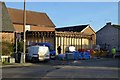
Shop renovation
At Depot Corner. Previously this had a rather nice date stone Image The Kennel Gate shop in that picture closed not long after it was followed by a conventional corner shop supermarket which lasted a few years. That closed about a year ago.
Image: © David Lally
Taken: 24 Feb 2017
0.10 miles
5
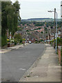
Oakdale Drive
Looking south. The spire of Attenborough Church Image can be seen in the distance.
Image: © Alan Murray-Rust
Taken: 6 Sep 2009
0.10 miles
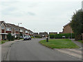
6
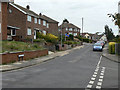
Redland Drive
1950s/60s housing development in Chilwell.
Image: © Alan Murray-Rust
Taken: 6 Sep 2009
0.10 miles
7
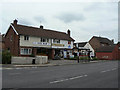
Worsley Pharmacy
Still surviving as a retail outlet. The building also contains a physiotherapy clinic.
Image: © Alan Murray-Rust
Taken: 6 Sep 2009
0.12 miles
8
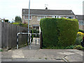
5 seconds or 5 minutes
About 5 seconds on foot to get from one end (Bolton Avenue) of this alley to the other (Oakdale Drive), but about 5 minutes by car. The distance by road is nearly 2 km.
Image: © Alan Murray-Rust
Taken: 6 Sep 2009
0.14 miles
9
Side Entrance to Chetwynd Barracks
View looking down Chetwynd Road; the main entrance to the barracks is on Swiney Way.
Image: © Oxymoron
Taken: 14 Aug 2008
0.14 miles
10
Northdown Drive
Roads on the south side of Field Lane were developed as private, not council, housing in the 1960s.
Image: © Alan Murray-Rust
Taken: 6 Sep 2009
0.17 miles