IMAGES TAKEN NEAR TO
Field Lane, NOTTINGHAM, NG9 5FF
Introduction
This page details the photographs taken nearby to Field Lane, NG9 5FF by members of the Geograph project.
The Geograph project started in 2005 with the aim of publishing, organising and preserving representative images for every square kilometre of Great Britain, Ireland and the Isle of Man.

There are currently over 7.5m images from over14,400 individuals and you can help contribute to the project by visiting https://www.geograph.org.uk
Image Map
Images are licensed for reuse under creativecommons.org/licenses/by-sa/2.0
Notes
- Clicking on the map will re-center to the selected point.
- The higher the marker number, the further away the image location is from the centre of the postcode.
Image Listing (97 Images Found)
Images are licensed for reuse under creativecommons.org/licenses/by-sa/2.0
Image
Details
Distance
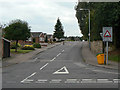
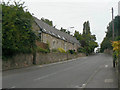
1
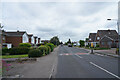
Field Lane
This whole journey around Stapleford and Chilwell has been along road with some very effective traffic calming bumps in the road. A couple of which you can see in this image.
Image: © Malcolm Neal
Taken: 24 Jun 2021
0.04 miles
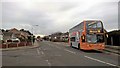
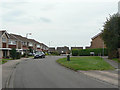
3
Eskdale Drive, Chilwell
From Field Lane.
Image: © Andrew Abbott
Taken: 21 Apr 2020
0.05 miles
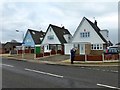
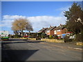
5
Field Lane
Now the main road round the south side of Inham Nook estate, it was once simply a farm lane.
Image: © Alan Murray-Rust
Taken: 6 Sep 2009
0.09 miles
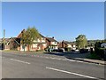
8
Field Lane, Chilwell, at Northdown Drive
There is a bench mark http://www.geograph.org.uk/photo/5159582 on the end wall of the house on the right.
Image: © Alan Murray-Rust
Taken: 17 Oct 2016
0.11 miles
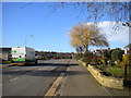
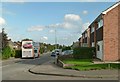
9
Northdown Drive
Roads on the south side of Field Lane were developed as private, not council, housing in the 1960s.
Image: © Alan Murray-Rust
Taken: 6 Sep 2009
0.12 miles
10
The old school, School Lane
Now converted to residential use. Old 6-inch maps show mark it as a Sunday School.
Image: © Alan Murray-Rust
Taken: 6 Sep 2009
0.13 miles