IMAGES TAKEN NEAR TO
Burnham Avenue, NOTTINGHAM, NG9 5AH
Introduction
This page details the photographs taken nearby to Burnham Avenue, NG9 5AH by members of the Geograph project.
The Geograph project started in 2005 with the aim of publishing, organising and preserving representative images for every square kilometre of Great Britain, Ireland and the Isle of Man.

There are currently over 7.5m images from over14,400 individuals and you can help contribute to the project by visiting https://www.geograph.org.uk
Image Map
Images are licensed for reuse under creativecommons.org/licenses/by-sa/2.0
Notes
- Clicking on the map will re-center to the selected point.
- The higher the marker number, the further away the image location is from the centre of the postcode.
Image Listing (112 Images Found)
Images are licensed for reuse under creativecommons.org/licenses/by-sa/2.0
Image
Details
Distance
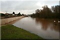
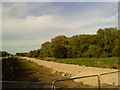
2
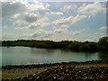
Flooded gravel pits between Beeston and Attenborough
Image: © Andrew Abbott
Taken: 20 May 2010
0.08 miles
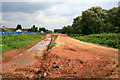
3
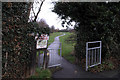
Path across Chilwell Manor Golf Club
Taken from the other end of the path to this Image On Barkers Lane Attenborough.
Image: © David Lally
Taken: 6 Dec 2007
0.08 miles
4
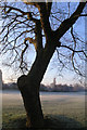
Frosty tree
On Chilwell Manor golf course.
Image: © David Lally
Taken: 11 Feb 2008
0.09 miles
5
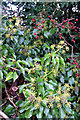
Hawthorn and Ivy
The hedge between Barkers Lane and the Chilwell Manor Golf Course
Image: © David Lally
Taken: 6 Dec 2007
0.10 miles
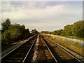
8
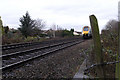
Train approaching foot level-crossing
Between the end of Meadow Lane and the Attenborough nature reserve
Image: © David Lally
Taken: 6 Dec 2007
0.12 miles
10
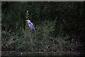
Heron (Ardea cinerea) on a branch
Beeston pond, Attenborough Nature Reserve.
Image: © David Lally
Taken: 24 Sep 2010
0.13 miles