IMAGES TAKEN NEAR TO
Bicycle Lane, NOTTINGHAM, NG9 4HG
Introduction
This page details the photographs taken nearby to Bicycle Lane, NG9 4HG by members of the Geograph project.
The Geograph project started in 2005 with the aim of publishing, organising and preserving representative images for every square kilometre of Great Britain, Ireland and the Isle of Man.

There are currently over 7.5m images from over14,400 individuals and you can help contribute to the project by visiting https://www.geograph.org.uk
Image Map
Images are licensed for reuse under creativecommons.org/licenses/by-sa/2.0
Notes
- Clicking on the map will re-center to the selected point.
- The higher the marker number, the further away the image location is from the centre of the postcode.
Image Listing (283 Images Found)
Images are licensed for reuse under creativecommons.org/licenses/by-sa/2.0
Image
Details
Distance
1
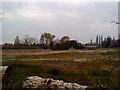
Wasteland off Queen's Road West, Beeston
Image: © Andrew Abbott
Taken: 12 Apr 2010
0.02 miles
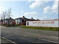
2
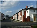
Barton Quarter, Chilwell, March 2022 ? 3
Bridge Avenue. The choice of neo-Regency style for these villas is not an obvious extension of existing local style.
The straight road is unusual for a modern development, but is constrained by the presence of a culverted stream under the road.
Image: © Alan Murray-Rust
Taken: 28 Mar 2022
0.02 miles
3
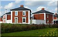
Barton Quarter, Chilwell, March 2022 ? 6
Houses in the style of a Regency villa.
Image: © Alan Murray-Rust
Taken: 28 Mar 2022
0.03 miles
4
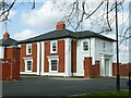
Barton Quarter, Chilwell, March 2022 ? 5
Semi-detached house in the style of a Regency villa.
Image: © Alan Murray-Rust
Taken: 28 Mar 2022
0.04 miles
5
Queen's Road West, Beeston
Peculiar constructions either side of the roadway.
Image: © Andrew Abbott
Taken: 12 Apr 2010
0.05 miles
6

Barton Quarter, Chilwell, March 2022 ? 4
This plot is now occupied.
Image: © Alan Murray-Rust
Taken: 28 Mar 2022
0.05 miles
7
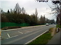
Flood bank humps beside Queens Road West
There is an OS benchmark Image on the roadface of the hump wall at the left hand side of the image
Image: © Roger Templeman
Taken: 3 Apr 2013
0.05 miles
8
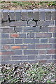
Benchmark on Queens Road West flood bank
Ordnance Survey cut mark benchmark described on the Bench Mark Database at http://www.bench-marks.org.uk/bm34710
Image: © Roger Templeman
Taken: 3 Apr 2013
0.05 miles
10
Barton Quarter, Chilwell, March 2022 ? 2
The hoarding surrounds what will be phase 2 of the development. Beyond are the houses of phase 1, already complete.
Image: © Alan Murray-Rust
Taken: 28 Mar 2022
0.05 miles