IMAGES TAKEN NEAR TO
Dawn View, NOTTINGHAM, NG9 3QU
Introduction
This page details the photographs taken nearby to Dawn View, NG9 3QU by members of the Geograph project.
The Geograph project started in 2005 with the aim of publishing, organising and preserving representative images for every square kilometre of Great Britain, Ireland and the Isle of Man.

There are currently over 7.5m images from over14,400 individuals and you can help contribute to the project by visiting https://www.geograph.org.uk
Image Map
Images are licensed for reuse under creativecommons.org/licenses/by-sa/2.0
Notes
- Clicking on the map will re-center to the selected point.
- The higher the marker number, the further away the image location is from the centre of the postcode.
Image Listing (20 Images Found)
Images are licensed for reuse under creativecommons.org/licenses/by-sa/2.0
Image
Details
Distance
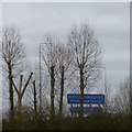
2
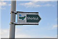
Shortcut
The sign doesn't say to where, though.
Image: © Andrew Tryon
Taken: 9 Oct 2020
0.15 miles
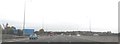
3
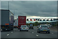
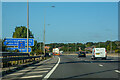
Broxtowe : M1 Motorway
The M1 Motorway between Junction 26 (Nuthall) and Junction 25 (Sandiacre).
Image: © Lewis Clarke
Taken: 3 Oct 2018
0.15 miles

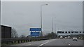
7
Trowell : M1 Motorway
Heading north through Derbyshire and into Nottinghamshire.
Image: © Lewis Clarke
Taken: 20 Sep 2020
0.17 miles