IMAGES TAKEN NEAR TO
Windsor Close, NOTTINGHAM, NG9 3PU
Introduction
This page details the photographs taken nearby to Windsor Close, NG9 3PU by members of the Geograph project.
The Geograph project started in 2005 with the aim of publishing, organising and preserving representative images for every square kilometre of Great Britain, Ireland and the Isle of Man.

There are currently over 7.5m images from over14,400 individuals and you can help contribute to the project by visiting https://www.geograph.org.uk
Image Map
Images are licensed for reuse under creativecommons.org/licenses/by-sa/2.0
Notes
- Clicking on the map will re-center to the selected point.
- The higher the marker number, the further away the image location is from the centre of the postcode.
Image Listing (38 Images Found)
Images are licensed for reuse under creativecommons.org/licenses/by-sa/2.0
Image
Details
Distance
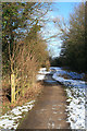
1

Former Nottingham Canal passing Grange Wood (1)
Here, the course of the filled in canal is followed by a public footpath (left) and public bridleway (right).
Image: © Richard Vince
Taken: 13 Dec 2014
0.07 miles
2
Development site near the Nottingham Canal
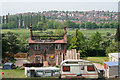
A derelict house, damaged by fire in 2004, receiving some loving care and attention, not before time either. This shot was taken just inside the adjacent square from the footpath along the old Nottingham Canal, which is now filled in this section. The town in the distance is Ilkeston in Derbyshire, the county boundary running along the River Erewash amongst the trees beyond the recreation field.
Image: © Kate Jewell
Taken: 12 May 2008
0.07 miles
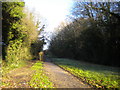
3
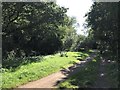
Path in Grange Wood near Trowell
Footpath following the line of the disused Nottingham Canal.
Image: © Jonathan Clitheroe
Taken: 21 Sep 2019
0.09 miles
4
From the footpath on the Nottingham Canal Nature Reserve
Looking south west from the public footpath towards the outskirts of Trowell with Hallam Fields in the far distance. The gardens on Ilkeston Road back up onto the Nature Reserve.
Image: © Kate Jewell
Taken: 12 May 2008
0.10 miles
5
Nottingham Canal Nature Reserve
Broxtowe Borough Council acquired most of the canal in 1977 and the site was declared a Local Nature Reserve in 1993. There is a footpath along the old towpath and a bridleway along the other bank. This section, from the Cossall Lane car park to Trowell, has been filled in. This view is looking along the bridleway towards the car park which is in Image
Image: © Kate Jewell
Taken: 12 May 2008
0.11 miles
6
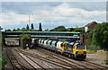
Train at Trowell Junction - (3)
A USA built class 70 diesel locomotive takes empty coal hoppers through Trowell Junction, south of Chesterfield.
Image: © The Carlisle Kid
Taken: 17 Jul 2012
0.11 miles
7

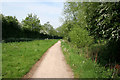
Footpath towards Ilkeston north of Trowell
This footpath goes from the former Nottingham Canal north of Trowell to the south eastern end of Ilkeston, crossing river and railway on the way.
Image: © Richard Vince
Taken: 13 Dec 2014
0.12 miles
8
Path Where the Canal Was
Course of the Nottingham Canal near Trowell.
Image: © David Lally
Taken: 7 Feb 2009
0.12 miles
9
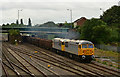
Train at Trowell Junction - (1)
A pair of class 56 diesel locomotives head an empty stone train north through Trowell Junction towards Chesterfield.
Image: © The Carlisle Kid
Taken: 17 Jul 2012
0.12 miles
10
Former Nottingham Canal passing Grange Wood (2)
For some reason, from here the adjacent public footpath (left) and public bridleway are separated from one another by a fence. This stretch of canal has been filled in, but the grassed area to the east of the paths was fairly boggy on this occasion.
Image: © Richard Vince
Taken: 13 Dec 2014
0.12 miles